1970s Maps of Hermedel, Louisiana
Explore 1 historic maps of Hermedel from the 1970s. These maps offer a rare glimpse into what life looked like during the 1970s — showing old roads, neighborhoods, homes, and landmarks that have changed or disappeared over time.
Whether you're researching your family's past, planning a metal detecting trip, or studying how Hermedel's landscape evolved across the 1970s, these high-resolution maps are a powerful tool for exploring the history of this region.
- Focus on a specific era: All maps on this page are from the 1970s, giving you a focused view of this time period.
- See what’s changed: Compare century-old streets, trails, and buildings to today's modern landscape using overlays and satellite layers.
- Research with precision: Use these maps for genealogy, historical research, land use analysis, or educational projects.
- View, download, or print: Maps are fully viewable online in high resolution, and can be downloaded or printed for your own records.
Start exploring Hermedel's history through authentic maps from the 1970s. This is your window into the past.
Hermedel, LA maps
(1)- 1971 Map of Slidell, 1972 Print
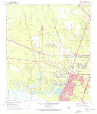 1971 Slidell1972 Print · USGSSlidell and the north shore of Lake Pontchartrain are captured here in the early seventies during a period of significant suburban and highway growth. Local researchers can trace family roots through numerous sites like Greenwood Cem or explore the grounds of Camp Villerre and Camp Salmen.5 unique versions available
End of results
Showing maps 1-1 of 1
Top cities near Hermedel
- New Orleans historical maps
- Slidell historical maps
- Picayune historical maps
- Abita Springs historical maps
- Pearlington historical maps
Frequently asked questions
- What are the different types of historical maps available for Hermedel?
- What is the oldest map of Hermedel?
- Where can I purchase historical maps of Hermedel for my home or office?
- Where can I download high-res historical maps of Hermedel?
- Are there historical topographic maps available for Hermedel?
- Is there historical aerial imagery available for Hermedel?
- Where are historical maps of Hermedel sourced from?