1930s Maps of Houma, Louisiana
Explore 3 historic maps of Houma from the 1930s. These maps offer a rare glimpse into what life looked like during the 1930s — showing old roads, neighborhoods, homes, and landmarks that have changed or disappeared over time.
Whether you're researching your family's past, planning a metal detecting trip, or studying how Houma's landscape evolved across the 1930s, these high-resolution maps are a powerful tool for exploring the history of this region.
- Focus on a specific era: All maps on this page are from the 1930s, giving you a focused view of this time period.
- See what’s changed: Compare century-old streets, trails, and buildings to today's modern landscape using overlays and satellite layers.
- Research with precision: Use these maps for genealogy, historical research, land use analysis, or educational projects.
- View, download, or print: Maps are fully viewable online in high resolution, and can be downloaded or printed for your own records.
Start exploring Houma's history through authentic maps from the 1930s. This is your window into the past.
Houma, LA maps
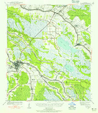
(3)- 1932 Map of Houma SW
 1932 Houma SW1932 Print · USGSCoastal Louisiana at the height of the early thirties shows a region defined by its water-bound industry and growing infrastructure. Genealogists and historians can trace family-named sites like Southdown and Ashland, or locate rural landmarks such as Jerusalem Ch and the Bayou Cane Sch.
 - 1939 Map of Gibson, 1956 Print
 1939 Gibson1956 Print · USGSCoastal Louisiana at the end of the thirties was a world of rail-side settlements and bayou-based commerce. You can trace the lineage of small parish communities through Beattieville Gray P O, Mt Pilgrim Ch, and the Halfway Cem.
 - 1939 Map of Houma, 1956 Print
 1939 Houma1956 Print · USGSCoastal Louisiana settlement follows the high ridges of the bayous just before the mid-century industrial boom. Genealogists can trace family names and rural landmarks from Aragon Plantation to the St Elie Cem and old Mechanicville neighborhoods.
End of results
Showing maps 1-3 of 3
Top cities near Houma
- Thibodaux historical maps
- Chauvin historical maps
- Lockport historical maps
- Dulac historical maps
- Montegut historical maps
Top neighborhoods of Houma
Frequently asked questions
- What are the different types of historical maps available for Houma?
- What is the oldest map of Houma?
- Where can I purchase historical maps of Houma for my home or office?
- Where can I download high-res historical maps of Houma?
- Are there historical topographic maps available for Houma?
- Is there historical aerial imagery available for Houma?
- Where are historical maps of Houma sourced from?