1940s Maps of Idlewild, Terrebonne Parish
Explore 5 historic maps of Idlewild from the 1940s. These maps offer a rare glimpse into what life looked like during the 1940s — showing old roads, neighborhoods, homes, and landmarks that have changed or disappeared over time.
Whether you're researching your family's past, planning a metal detecting trip, or studying how Idlewild's landscape evolved across the 1940s, these high-resolution maps are a powerful tool for exploring the history of this region.
- Focus on a specific era: All maps on this page are from the 1940s, giving you a focused view of this time period.
- See what’s changed: Compare century-old streets, trails, and buildings to today's modern landscape using overlays and satellite layers.
- Research with precision: Use these maps for genealogy, historical research, land use analysis, or educational projects.
- View, download, or print: Maps are fully viewable online in high resolution, and can be downloaded or printed for your own records.
Start exploring Idlewild's history through authentic maps from the 1940s. This is your window into the past.
Idlewild, Terrebonne Parish maps
(5)- 1941 Map of Houma
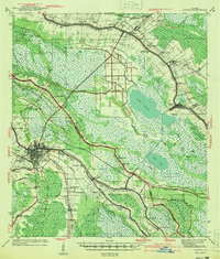 1941 Houma1941 Print · USGSIn the bayou country just before the war, the region around Houma shows a complex web of water-based trade and rail-linked industry. Researchers can trace historic parish life through family-named landmarks and institutions like Aragon Plantation, St Elie Cem, and the Prairie Sch.
 - 1941 Map of Gibson
 1941 Gibson1941 Print · USGSCajun country and the sugarcane belt are mapped here just before the war, showing the rail-and-water corridors of the southern parishes. Genealogists can trace family names and local landmarks through sites like Beattleville Gray P O, Bull Run Sch, and Halfway Cem.
 - 1944 Map of Houma
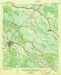 1944 Houma1944 Print · USGSCoastal Louisiana during the mid-forties reveals a landscape shaped by its bayous and the early expansion of the Intracoastal Waterway. Researchers can trace genealogical roots through local landmarks like Aragon Plantation, St Elie Cem, and St Louis Chapel.
 - 1944 Map of Gibson
 1944 Gibson1944 Print · USGSCoastal Louisiana during the mid-forties reveals a landscape defined by delta bayous and early industrial rail lines. Genealogists can locate family landmarks like Mt Pilgrim Ch, St Johns Ch, and the Beattieville Gray PO.
 - 1945 Map of New Orleans
 1945 New Orleans1945 Print · USGSCoastal Louisiana and the Mississippi delta are captured here just after the war, showing the region's transition into a modern industrial and transit hub. Genealogists can trace family settlements along Bayou Teche or identify rail stops for the Illinois Central and Texas & Pacific lines.
End of results
Showing maps 1-5 of 5
Frequently asked questions
- What are the different types of historical maps available for Idlewild?
- What is the oldest map of Idlewild?
- Where can I purchase historical maps of Idlewild for my home or office?
- Where can I download high-res historical maps of Idlewild?
- Are there historical topographic maps available for Idlewild?
- Is there historical aerial imagery available for Idlewild?
- Where are historical maps of Idlewild sourced from?