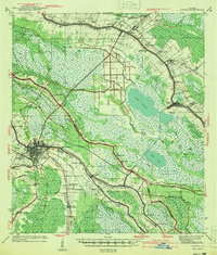
1941 Map of Houma
USGS Topo · Published 1941About this map
Houma and its surrounding wetlands are meticulously documented just before the United States entered World War II, revealing a landscape defined by the convergence of major bayous and early industrial development. The city serves as a hub for the Southern Pacific railroad and the Intracoastal Waterway, with residential growth extending into Mechanicville. The era's dependence on the water is evident in the numerous settlements lining the banks of Bayou Lafourche, including Lockport, Rita, and Mathews.
Find a feature on this map
70 named features on this map. Tap any name to fly to it.
Don’t see what you’re looking for? This feature index may not catch every label — zoom into the map to look around manually.
Map Details
Editions of this 1941 Houma Map
This is the sole edition of this map. No revisions or reprints were ever made.
Other maps of this area

1891 · Hahnville
USGS Topo · 1:62,500

1892 · Lac Des Allemands
USGS Topo · 1:62,500

1892 · Gibson
USGS Topo · 1:62,500

1892 · Cut-Off
USGS Topo · 1:62,500

1892 · Houma
USGS Topo · 1:62,500

1892 · Thibodaux
USGS Topo · 1:62,500

1894 · Bayou De Large
USGS Topo · 1:62,500

1894 · Lake Felicity
USGS Topo · 1:62,500

1894 · Dulac
USGS Topo · 1:62,500

1897 · Gibson
USGS Topo · 1:62,500