1980s Maps of Cole Central, Louisiana
Explore 2 historic maps of Cole Central from the 1980s. These maps offer a rare glimpse into what life looked like during the 1980s — showing old roads, neighborhoods, homes, and landmarks that have changed or disappeared over time.
Whether you're researching your family's past, planning a metal detecting trip, or studying how Cole Central's landscape evolved across the 1980s, these high-resolution maps are a powerful tool for exploring the history of this region.
- Focus on a specific era: All maps on this page are from the 1980s, giving you a focused view of this time period.
- See what’s changed: Compare century-old streets, trails, and buildings to today's modern landscape using overlays and satellite layers.
- Research with precision: Use these maps for genealogy, historical research, land use analysis, or educational projects.
- View, download, or print: Maps are fully viewable online in high resolution, and can be downloaded or printed for your own records.
Start exploring Cole Central's history through authentic maps from the 1980s. This is your window into the past.
Cole Central, LA maps
(2)- 1986 Map of Sugrue
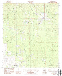 1986 Sugrue1986 Print · USGSWithin the pine woods of Vernon Parish in the mid-1980s, these forest lands reveal scattered settlements and rural landmarks. Researchers can trace local homesteads and industry through labels for Cole Central, the Gravel Pit, and the winding Whisky Chitto Creek.2 unique versions available
 - 1986 Map of DeRidder
 1986 DeRidder1986 Print · USGSThe Louisiana-Texas borderlands come to life in the mid-eighties, showcasing the timber country and rail corridors of the Sabine River valley. Researchers can trace the legacy of small communities and transit lines through Merryville, Holly Springs, and the Missouri Pacific railroad.2 unique versions available
End of results
Showing maps 1-2 of 2
Top cities near Cole Central
Frequently asked questions
- What are the different types of historical maps available for Cole Central?
- What is the oldest map of Cole Central?
- Where can I purchase historical maps of Cole Central for my home or office?
- Where can I download high-res historical maps of Cole Central?
- Are there historical topographic maps available for Cole Central?
- Is there historical aerial imagery available for Cole Central?
- Where are historical maps of Cole Central sourced from?