1980s Maps of Pioneer, Louisiana
Explore 2 historic maps of Pioneer from the 1980s. These maps offer a rare glimpse into what life looked like during the 1980s — showing old roads, neighborhoods, homes, and landmarks that have changed or disappeared over time.
Whether you're researching your family's past, planning a metal detecting trip, or studying how Pioneer's landscape evolved across the 1980s, these high-resolution maps are a powerful tool for exploring the history of this region.
- Focus on a specific era: All maps on this page are from the 1980s, giving you a focused view of this time period.
- See what’s changed: Compare century-old streets, trails, and buildings to today's modern landscape using overlays and satellite layers.
- Research with precision: Use these maps for genealogy, historical research, land use analysis, or educational projects.
- View, download, or print: Maps are fully viewable online in high resolution, and can be downloaded or printed for your own records.
Start exploring Pioneer's history through authentic maps from the 1980s. This is your window into the past.
Pioneer, LA maps
(2)- 1982 Map of Bastrop, 1983 Print
 1982 Bastrop1983 Print · USGSNortheastern Louisiana and the Mississippi River Delta are captured here in the early eighties as a landscape of bayous and river towns. Genealogists and historians can trace small communities like Mer Rouge and Oak Grove or the ancient terrain of Poverty Point State Park.
 - 1986 Map of Pioneer, 1987 Print
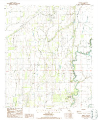 1986 Pioneer1987 Print · USGSThe West Carroll Parish agricultural landscape is captured here in the mid-1980s, centered on the ancient earthworks of the Mississippi Delta. Genealogists and researchers can trace the rail corridor of the Missouri Pacific through Pioneer and Darnell, or locate the historic Indian Mound near Poverty Point State Park.
End of results
Showing maps 1-2 of 2
Top cities near Pioneer
Frequently asked questions
- What are the different types of historical maps available for Pioneer?
- What is the oldest map of Pioneer?
- Where can I purchase historical maps of Pioneer for my home or office?
- Where can I download high-res historical maps of Pioneer?
- Are there historical topographic maps available for Pioneer?
- Is there historical aerial imagery available for Pioneer?
- Where are historical maps of Pioneer sourced from?