Old Maps of Androscoggin County, Maine for Academic Research
Study the evolution of Androscoggin County with 158 high-resolution historic maps. Whether you're teaching, researching, or modeling changes in land use, these maps provide essential visual documentation of urban, environmental, and geographic change.
- Analyze long-term change: Track patterns in development, transportation, and natural features.
- Ideal for environmental or urban studies: Support academic projects with primary historical map data.
- Use in the classroom or lab: Educators and researchers rely on these maps to bring historical context to life.
These maps are a powerful tool for teaching, research, and visualizing how Androscoggin County has changed over the decades.
Androscoggin County, ME maps
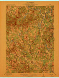
(158)- 1892 Map of Gardiner
 1892 Gardiner1892 Print · USGSThe Kennebec River valley in the 1890s was a bustling corridor of rail and river commerce. Genealogists and historians can trace old homesteads and landings from Gardiner down to Bowdoinham, including points like Ship Yard Pt and the grounds of the Richmond Campmeeting.7 unique versions available
 - 1892 Map of Freeport
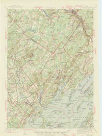
 1892 Freeport1892 Print · USGSCumberland County coastal life in the 1890s centered on the busy intersections of rail and tide. Genealogists and historians can trace the old shipping hubs at Mast Landing, the many islands of Casco Bay, and the rail corridors at Yarmouth Junction.9 unique versions available
 - 1894 Map of Gray
 1894 Gray1894 Print · USGSMaine's Sebago Lake region at the close of the nineteenth century shows a network of mill towns and early rail lines. Trace family roots and vanished landmarks through New Gloucester, Sabbathday Lake, and the depots along the Maine Central R. R.
 - 1898 Map of Gray
 1898 Gray1898 Print · USGSIn the 1890s, this area of southern Maine was a landscape of evolving rail connections and traditional mill towns. Genealogists can trace family roots through settlements like New Gloucester and Cumberland Center, or locate early landmarks such as Webbs Mills and Sabbathday Lake.7 unique versions available
 - 1908 Map of Poland
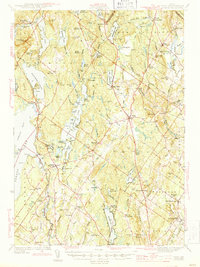
 1908 Poland1908 Print · USGSAndroscoggin County was a thriving hub of rail transport and lakeside resorts in the early nineteen-hundreds. Here you can trace the historic Grand Trunk Railway corridor through Mechanic Falls and locate the famous Poland Spring resort grounds.5 unique versions available
 - 1908 Map of Lewiston
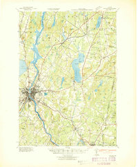
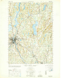
 1908 Lewiston1908 Print · USGSAndroscoggin County at the start of the century shows a thriving industrial corridor centered on the twin cities and the river. Genealogists can trace family farms and local institutions near Sabattus Pond, Bates College, and Lisbon Falls.6 unique versions available
 - 1910 Map of Livermore, 1959 Print
 1910 Livermore1959 Print · USGSMaine's river valleys and lake districts are captured here in the early twentieth century, showing a network of rail-reliant mill towns and rural crossroads. Genealogists can locate family landmarks like Howes Corner and Brettuns Mills, or trace local schools like Saunders School.
 - 1911 Map of Buckfield, 1958 Print
 1911 Buckfield1958 Print · USGSOxford County at the dawn of the twentieth century was a landscape of high ridges and tight river valleys connected by new rail lines. Genealogists can locate dozens of district schoolhouses like Bonney School and rural hubs such as Buckfield and Brettuns Mills Livermore P O.
 - 1912 Map of Livermore
 1912 Livermore1912 Print · USGSMaine's lake district comes to life in this pre-war survey of the Androscoggin River valley. Genealogists and historians can trace old homesteads and landmarks like Brettuns Mills Livermore P O, Strickland Ferry, and Monmouth Academy.5 unique versions available
 - 1913 Map of Buckfield
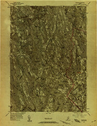
 1913 Buckfield1913 Print · USGSOxford County towns and mountain peaks are captured here in the early twentieth century. Researchers can trace rural family roots through numerous named schoolhouses like the Meadowview Academy, Jones School, and the Bear Mountain School.5 unique versions available
 - 1940 Map of Poland, 1942 Print
 1940 Poland1942 Print · USGSMaine's river valleys and rail junctions come to life in the 1940s as the region's industrial and rural networks are captured in detail. Genealogists can trace family landmarks like Hebron Sta P O, the Sanitarium, and the busy hub at Mechanic Falls.
 - 1941 Map of Livermore
 1941 Livermore1941 Print · USGSAndroscoggin County at the start of the 1940s is a landscape defined by the river and rail economy between Livermore Falls and Wayne. Genealogists can trace family footprints across numerous rural districts, locating Brettuns Mills and the many schoolhouses like Young Sch and Pike Sch.
 - 1941 Map of Freeport, 1957 Print
 1941 Freeport1957 Print · USGSCumberland County at the dawn of the 1940s shows a landscape defined by the Androscoggin River and the rugged shoreline of Casco Bay. Local researchers can trace family roots through numerous burial grounds like Elmlawn Cem or locate forgotten schoolhouses like Hacker Sch and Hicks Sch.
 - 1942 Map of Lewiston
 1942 Lewiston1942 Print · USGSLewiston and the Androscoggin River valley are shown in detail during the early 1940s, capturing the area's transition from industrial hubs to rural crossroads. Researchers can locate early schoolhouses like No Name Sch, the campus of Bates College, and vanished rail stops at Golder Siding and Leeds Junc.
 - 1942 Map of Buckfield
 1942 Buckfield1942 Print · USGSOxford County and the upper Androscoggin valley are shown in detail during the early 1940s as the railroad still anchored the local economy. Genealogists and researchers can trace dozens of rural schoolhouses and family landmarks like Mt Oxford Spring, Brettuns Mills, and the Maine Central rail line.
 - 1942 Map of Poland
 1942 Poland1942 Print · USGSSouth-central Maine is captured here in the early 1940s, showing a landscape of rail-linked mill towns and hilltop farms. Genealogists can trace family names at Hebron Sta P O, Danville Corner, and the Empire Grove Campground.
 - 1942 Map of Gray, 1956 Print
 1942 Gray1956 Print · USGSCumberland County’s interior landscape comes into focus during the early 1940s, revealing a network of rail-side stations and crossroads hamlets. Genealogists and historians can trace family locations near Suckerville, Purinton Cem, and the Friends Ch.
 - 1943 Map of Gardiner
 1943 Gardiner1943 Print · USGSThe Kennebec River valley in the early 1940s reveals a landscape of riverside industry and inland farming communities. Researchers can trace ancestral roots through dozens of local schoolhouses like J F Stevens Sch and family crossroads such as Spears Cor or Starbird Cor.4 unique versions available
 - 1944 Map of Gray
 1944 Gray1944 Print · USGSCumberland County village life and the rail-and-water economy are captured here just after the war. You can trace the Maine Central line through several depots or locate historic family landmarks like Purinton Cem and the Opportunity Sch.3 unique versions available
 - 1944 Map of Freeport
 1944 Freeport1944 Print · USGSCumberland County’s rugged shoreline and industrial river valleys are captured during the early 1940s, from the mills of the Androscoggin River to the islands of Casco Bay. Researchers can trace the legacy of local families through landmarks like Plummer Mill, Hacker Sch, and the Lunt Memorial Cem.3 unique versions available
 - 1948 Map of Bangor
 1948 Bangor1948 Print · USGSThe Maine coast and its industrial river valleys are captured here shortly after the war, showing the vital shipping and rail hubs of the late 1940s. Genealogists and historians can trace the tracks of the Maine Central RR connecting Bangor, Augusta, and Old Town.
 - 1949 Map of Portland
 1949 Portland1949 Print · USGSCoastal Maine and the New Hampshire interior are shown in detail during the late forties, from the bustling harbors to the lakeside villages. Researchers can trace historical rail networks like the Boston & Maine RR and locate coastal defenses such as Fort Preble.3 unique versions available
 - 1950 Map of Lewiston
 1950 Lewiston1950 Print · USGSAndroscoggin County at mid-century shows a landscape of busy industrial centers and quiet crossroad hamlets connected by the river. Genealogists can trace family names at Jordan Corners or Blake Corners and locate rural landmarks like Sprague Mill and Ridge Sch.
 - 1950 Map of Lewiston
 1950 Lewiston1950 Print · USGSThe Maine and New Hampshire borderlands come alive in this post-war survey of the White Mountains and Androscoggin valley. Genealogists and historians can trace rail lines like the Maine Central Railroad and find high-altitude landmarks from Mount Washington to Bretton Woods.2 unique versions available
 - 1956 Map of Poland, 1958 Print
 1956 Poland1958 Print · USGSMid-Maine's river valleys and hillsides are documented here during the mid-fifties, featuring a landscape of paper mills, sanatoriums, and rural hamlets. Researchers can trace the busy rail junctions at Danville Jct or locate the historic resort grounds at Poland Spring.4 unique versions available
Showing maps 1-25 of 158
Top cities of Androscoggin County
- Lewiston historical maps
- Auburn historical maps
- Lisbon historical maps
- Turner historical maps
- Poland historical maps
- Sabattus historical maps
See more
Frequently asked questions
- What are the different types of historical maps available for Androscoggin County?
- What is the oldest map of Androscoggin County?
- Where can I purchase historical maps of Androscoggin County for my home or office?
- Where can I download high-res historical maps of Androscoggin County?
- Are there historical topographic maps available for Androscoggin County?
- Is there historical aerial imagery available for Androscoggin County?
- Where are historical maps of Androscoggin County sourced from?