1970s Maps of Auburn, Maine
Explore 3 historic maps of Auburn from the 1970s. These maps offer a rare glimpse into what life looked like during the 1970s — showing old roads, neighborhoods, homes, and landmarks that have changed or disappeared over time.
Whether you're researching your family's past, planning a metal detecting trip, or studying how Auburn's landscape evolved across the 1970s, these high-resolution maps are a powerful tool for exploring the history of this region.
- Focus on a specific era: All maps on this page are from the 1970s, giving you a focused view of this time period.
- See what’s changed: Compare century-old streets, trails, and buildings to today's modern landscape using overlays and satellite layers.
- Research with precision: Use these maps for genealogy, historical research, land use analysis, or educational projects.
- View, download, or print: Maps are fully viewable online in high resolution, and can be downloaded or printed for your own records.
Start exploring Auburn's history through authentic maps from the 1970s. This is your window into the past.
Auburn, ME maps
(3)- 1979 Map of Lewiston
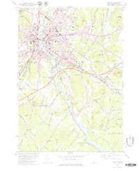 1979 Lewiston1979 Print · USGSThe twin cities of Lewiston and Auburn are shown in the late seventies as they grew along the Androscoggin River. Researchers can locate many family-named crossroads and burial sites, including Penley Corner, Beth Abraham Cem, and Royal Corner.2 unique versions available
 - 1979 Map of Lake Auburn East
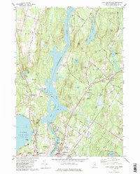 1979 Lake Auburn East1979 Print · USGSAndroscoggin County comes into focus in the late seventies, showing the river-driven industry and rural townships of the Lewiston-Auburn area. Genealogists and local historians can trace family plots at St Peters Cem or Valley Cem and locate landmarks like the Greene Central Sch.
 - 1979 Map of North Pownal
 1979 North Pownal1979 Print · USGSCoastal Maine's interior comes to life in the late seventies as the Grand Trunk RR cuts through the communities of North Pownal and Pownal Center. Genealogists and hikers can trace family-named cemeteries like McKenney Cem or explore the early layout of Bradbury Mtn State Park.2 unique versions available
End of results
Showing maps 1-3 of 3
Top cities near Auburn
- Lewiston historical maps
- Brunswick historical maps
- Windham historical maps
- Standish historical maps
- Lisbon historical maps
- Topsham historical maps
See more
Top neighborhoods of Auburn
- West Auburn historical maps
- Youngs Corner historical maps
- North Auburn historical maps
- Auburn Plains historical maps
- Danville historical maps
- Danville Corner historical maps
See more
Frequently asked questions
- What are the different types of historical maps available for Auburn?
- What is the oldest map of Auburn?
- Where can I purchase historical maps of Auburn for my home or office?
- Where can I download high-res historical maps of Auburn?
- Are there historical topographic maps available for Auburn?
- Is there historical aerial imagery available for Auburn?
- Where are historical maps of Auburn sourced from?