Old Maps of Auburn, Maine for Genealogy
Trace your family roots with 64 historic maps of Auburn. These high-res maps reveal old neighborhoods, homesites, landmarks, and streets — helping you uncover where your ancestors lived and how the area evolved over time.
- Explore historic neighborhoods: Identify where your relatives may have lived in the 1800s or 1900s.
- Compare maps over time: Trace the changes in streets, buildings, and landmarks for multi-generational research.
- Perfect for genealogy & ancestry research: Used by family historians and researchers to map out lineage and migration.
These maps are an incredible resource for exploring your personal connection to Auburn's past.
Auburn, ME maps
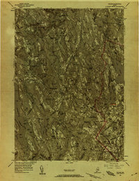
(64)- 1892 Map of Freeport
 1892 Freeport1892 Print · USGSCumberland County coastal life in the 1890s centered on the busy intersections of rail and tide. Genealogists and historians can trace the old shipping hubs at Mast Landing, the many islands of Casco Bay, and the rail corridors at Yarmouth Junction.9 unique versions available
 - 1894 Map of Gray
 1894 Gray1894 Print · USGSMaine's Sebago Lake region at the close of the nineteenth century shows a network of mill towns and early rail lines. Trace family roots and vanished landmarks through New Gloucester, Sabbathday Lake, and the depots along the Maine Central R. R.
 - 1898 Map of Gray
 1898 Gray1898 Print · USGSIn the 1890s, this area of southern Maine was a landscape of evolving rail connections and traditional mill towns. Genealogists can trace family roots through settlements like New Gloucester and Cumberland Center, or locate early landmarks such as Webbs Mills and Sabbathday Lake.7 unique versions available
 - 1908 Map of Poland
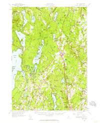
 1908 Poland1908 Print · USGSAndroscoggin County was a thriving hub of rail transport and lakeside resorts in the early nineteen-hundreds. Here you can trace the historic Grand Trunk Railway corridor through Mechanic Falls and locate the famous Poland Spring resort grounds.5 unique versions available
 - 1908 Map of Lewiston
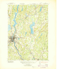
 1908 Lewiston1908 Print · USGSAndroscoggin County at the start of the century shows a thriving industrial corridor centered on the twin cities and the river. Genealogists can trace family farms and local institutions near Sabattus Pond, Bates College, and Lisbon Falls.6 unique versions available
 - 1940 Map of Poland, 1942 Print
 1940 Poland1942 Print · USGSMaine's river valleys and rail junctions come to life in the 1940s as the region's industrial and rural networks are captured in detail. Genealogists can trace family landmarks like Hebron Sta P O, the Sanitarium, and the busy hub at Mechanic Falls.
 - 1941 Map of Freeport, 1957 Print
 1941 Freeport1957 Print · USGSCumberland County at the dawn of the 1940s shows a landscape defined by the Androscoggin River and the rugged shoreline of Casco Bay. Local researchers can trace family roots through numerous burial grounds like Elmlawn Cem or locate forgotten schoolhouses like Hacker Sch and Hicks Sch.
 - 1942 Map of Lewiston
 1942 Lewiston1942 Print · USGSLewiston and the Androscoggin River valley are shown in detail during the early 1940s, capturing the area's transition from industrial hubs to rural crossroads. Researchers can locate early schoolhouses like No Name Sch, the campus of Bates College, and vanished rail stops at Golder Siding and Leeds Junc.
 - 1942 Map of Poland
 1942 Poland1942 Print · USGSSouth-central Maine is captured here in the early 1940s, showing a landscape of rail-linked mill towns and hilltop farms. Genealogists can trace family names at Hebron Sta P O, Danville Corner, and the Empire Grove Campground.
 - 1942 Map of Gray, 1956 Print
 1942 Gray1956 Print · USGSCumberland County’s interior landscape comes into focus during the early 1940s, revealing a network of rail-side stations and crossroads hamlets. Genealogists and historians can trace family locations near Suckerville, Purinton Cem, and the Friends Ch.
 - 1944 Map of Gray
 1944 Gray1944 Print · USGSCumberland County village life and the rail-and-water economy are captured here just after the war. You can trace the Maine Central line through several depots or locate historic family landmarks like Purinton Cem and the Opportunity Sch.3 unique versions available
 - 1944 Map of Freeport
 1944 Freeport1944 Print · USGSCumberland County’s rugged shoreline and industrial river valleys are captured during the early 1940s, from the mills of the Androscoggin River to the islands of Casco Bay. Researchers can trace the legacy of local families through landmarks like Plummer Mill, Hacker Sch, and the Lunt Memorial Cem.3 unique versions available
 - 1949 Map of Portland
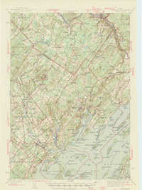
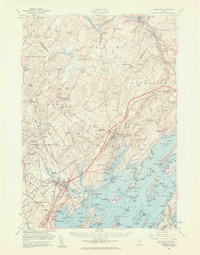
 1949 Portland1949 Print · USGSCoastal Maine and the New Hampshire interior are shown in detail during the late forties, from the bustling harbors to the lakeside villages. Researchers can trace historical rail networks like the Boston & Maine RR and locate coastal defenses such as Fort Preble.3 unique versions available
 - 1950 Map of Lewiston
 1950 Lewiston1950 Print · USGSAndroscoggin County at mid-century shows a landscape of busy industrial centers and quiet crossroad hamlets connected by the river. Genealogists can trace family names at Jordan Corners or Blake Corners and locate rural landmarks like Sprague Mill and Ridge Sch.
 - 1950 Map of Lewiston
 1950 Lewiston1950 Print · USGSThe Maine and New Hampshire borderlands come alive in this post-war survey of the White Mountains and Androscoggin valley. Genealogists and historians can trace rail lines like the Maine Central Railroad and find high-altitude landmarks from Mount Washington to Bretton Woods.2 unique versions available
 - 1956 Map of Poland, 1958 Print
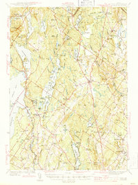
 1956 Poland1958 Print · USGSMid-Maine's river valleys and hillsides are documented here during the mid-fifties, featuring a landscape of paper mills, sanatoriums, and rural hamlets. Researchers can trace the busy rail junctions at Danville Jct or locate the historic resort grounds at Poland Spring.4 unique versions available
 - 1956 Map of Lewiston, 1958 Print
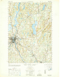
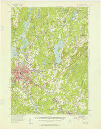 1956 Lewiston1958 Print · USGSThe industrial twin cities of Lewiston and Auburn thrive along the Androscoggin River during the mid-fifties. Genealogists and historians can trace the legacy of Bates College, the busy Maine Central Railroad corridors, and dozens of rural burying grounds like St Peters Cem.4 unique versions available
 - 1956 Map of Portland, 1963 Print
 1956 Portland1963 Print · USGSSouthern Maine and eastern New Hampshire are captured here in the mid-fifties, during a time of major highway expansion and military growth. You can trace the path of the Maine Turnpike and locate landmarks like the Portsmouth Naval Shipyard and Sebago Lake.4 unique versions available
 - 1956 Map of Lewiston, 1975 Print
 1956 Lewiston1975 Print · USGSThe Northern New England interior is documented here in the mid-fifties, from the industrial Androscoggin River to the high peaks of the White Mountains. Trace the Grand Trunk Railway through mountain passes or locate family landmarks near Sabbathday Lake and Bretton Woods.
 - 1957 Map of Gray, 1960 Print
 1957 Gray1960 Print · USGSCumberland County during the mid-fifties shows a landscape of established rail towns and growing turnpike access. Genealogists and historians can trace family locations near crossroads like Ireland Corner, find old schools such as Gloucester Hill School, and locate rural landmarks like Windham Plains Chapel.5 unique versions available
 - 1957 Map of Freeport, 1961 Print
 1957 Freeport1961 Print · USGSCoastal and rural Maine intersect in the late fifties as the turnpike begins to reshape the landscape from the Androscoggin River to Casco Bay. Genealogists can trace family names at Lunt Memorial Cem or explore the settlements of Shiloh and Durham Southwest Bend.3 unique versions available
 - 1959 Map of Portland
 1959 Portland1959 Print · USGSThe Maine and New Hampshire coastlines meet in this mid-century portrait of maritime commerce and inland rail networks. Researchers can trace the legacy of coastal defense at Fort Williams and follow the historic path of the Maine Central RR through the White Mountain National Forest.2 unique versions available
 - 1961 Map of Lewiston
 1961 Lewiston1961 Print · USGSWestern Maine and the White Mountains appear here during the early sixties, showing the industrial river towns and vast timberlands before the modern interstate era. Genealogists and historians can trace the Grand Trunk RR through Berlin or locate landmarks like Old Speck Mountain and Elephant Mountain.
 - 1962 Map of Lewiston
 1962 Lewiston1962 Print · USGSThe industrial river valleys and high peaks of Maine and New Hampshire define the region in the early sixties. Trace the rail-and-river network from Lewiston to the White Mountains, passing through mill towns like Berlin and Rumford.
 - 1963 Map of Portland
 1963 Portland1963 Print · USGSCoastal Maine and New Hampshire thrived as maritime and industrial hubs during the mid-sixties, linked by a dense network of rail and river. Researchers can trace historic transit corridors like the Maine Central RR and locate key sites such as the Portsmouth Naval Shipyard or Pease Air Force Base.3 unique versions available
Showing maps 1-25 of 64
Top cities near Auburn
- Lewiston historical maps
- Brunswick historical maps
- Windham historical maps
- Standish historical maps
- Lisbon historical maps
- Topsham historical maps
See more
Top neighborhoods of Auburn
- West Auburn historical maps
- Youngs Corner historical maps
- North Auburn historical maps
- Auburn Plains historical maps
- Danville historical maps
- Danville Corner historical maps
See more
Frequently asked questions
- What are the different types of historical maps available for Auburn?
- What is the oldest map of Auburn?
- Where can I purchase historical maps of Auburn for my home or office?
- Where can I download high-res historical maps of Auburn?
- Are there historical topographic maps available for Auburn?
- Is there historical aerial imagery available for Auburn?
- Where are historical maps of Auburn sourced from?