1900s (20th Century) Maps of Estcourt Station, Big Twenty Township
Explore 4 historic maps of Estcourt Station from the 1900s (20th Century). These maps offer a rare glimpse into what life looked like during the 1900s — showing old roads, neighborhoods, homes, and landmarks that have changed or disappeared over time.
Whether you're researching your family's past, planning a metal detecting trip, or studying how Estcourt Station's landscape evolved across the 1900s, these high-resolution maps are a powerful tool for exploring the history of this region.
- Focus on a specific era: All maps on this page are from the 1900s, giving you a focused view of this time period.
- See what’s changed: Compare century-old streets, trails, and buildings to today's modern landscape using overlays and satellite layers.
- Research with precision: Use these maps for genealogy, historical research, land use analysis, or educational projects.
- View, download, or print: Maps are fully viewable online in high resolution, and can be downloaded or printed for your own records.
Start exploring Estcourt Station's history through authentic maps from the 1900s. This is your window into the past.
Estcourt Station, Big Twenty Township maps
(4)- 1955 Map of Beau Lake, 1956 Print
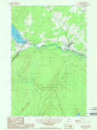
 1955 Beau Lake1956 Print · USGSThe Aroostook County borderlands are shown in the mid-fifties at the transition between Maine and Quebec. Researchers can trace the international line through Estcourt, locate the Customs Office, and follow old logging routes past Beau Lake and Kelly Rapids.2 unique versions available
 - 1962 Map of Edmundston, 1966 Print
 1962 Edmundston1966 Print · USGSThe international borderlands of northern Maine and Canada come alive here during the early sixties, centered on the river-and-rail economies of the day. Genealogists and historians can trace the paths of the Bangor and Aroostook railroad through river towns like Fort Kent and St Agatha.2 unique versions available
 - 1987 Map of Estcourt
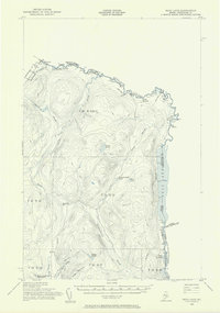
 1987 Estcourt1987 Print · USGSIn the remote Maine north woods during the late 1980s, the international border is more than just a line. Genealogists and local historians can trace the interconnected settlements of Estcourt and Sully along the St Francis River and Lac Pohénégamook.
 - 1993 Map of Allagash, 1994 Print
 1993 Allagash1994 Print · USGSThe Maine-Quebec borderlands in the early nineties show a landscape of deep timber and international riverways. Researchers can trace the remote settlements of Allagash and Dickey or locate historic river features like Castonia Rapids and Beau Lake.
End of results
Showing maps 1-4 of 4
Frequently asked questions
- What are the different types of historical maps available for Estcourt Station?
- What is the oldest map of Estcourt Station?
- Where can I purchase historical maps of Estcourt Station for my home or office?
- Where can I download high-res historical maps of Estcourt Station?
- Are there historical topographic maps available for Estcourt Station?
- Is there historical aerial imagery available for Estcourt Station?
- Where are historical maps of Estcourt Station sourced from?