1980s Maps of Fort Fairfield, Maine
Explore 4 historic maps of Fort Fairfield from the 1980s. These maps offer a rare glimpse into what life looked like during the 1980s — showing old roads, neighborhoods, homes, and landmarks that have changed or disappeared over time.
Whether you're researching your family's past, planning a metal detecting trip, or studying how Fort Fairfield's landscape evolved across the 1980s, these high-resolution maps are a powerful tool for exploring the history of this region.
- Focus on a specific era: All maps on this page are from the 1980s, giving you a focused view of this time period.
- See what’s changed: Compare century-old streets, trails, and buildings to today's modern landscape using overlays and satellite layers.
- Research with precision: Use these maps for genealogy, historical research, land use analysis, or educational projects.
- View, download, or print: Maps are fully viewable online in high resolution, and can be downloaded or printed for your own records.
Start exploring Fort Fairfield's history through authentic maps from the 1980s. This is your window into the past.
Fort Fairfield, ME maps
(4)- 1984 Map of Easton
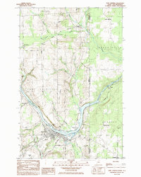
 1984 Easton1984 Print · USGSAroostook County's rail and river economy is on full display in the early eighties as the Bangor and Aroostook lines connect rural hubs. Trace the layout of settlements like Easton Station, Parkhurst, and Phair alongside landmarks like Gould Memorial Hospital.
 - 1984 Map of Easton Center
 1984 Easton Center1984 Print · USGSThe Aroostook County borderlands in the early 1980s reveal a quiet landscape of cross-border commerce and rail-connected hamlets. Genealogists and local historians can trace family locations near Easton Center, Mt Shilo Cem, and the Bangor and Aroostook line.
 - 1984 Map of Fort Fairfield, 1985 Print
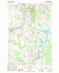
 1984 Fort Fairfield1985 Print · USGSThe Aroostook River valley during the early eighties shows a bustling international border region defined by rail and river commerce. Genealogists can trace family names at Riverside Cem and St Denis Ch or locate the old Turner Settlement.
 - 1984 Map of Goodwin, 1985 Print
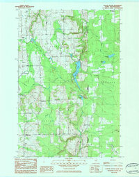
 1984 Goodwin1985 Print · USGSAroostook County's river-and-rail corridor is captured here in the early 1980s, showing the intersection of international rail lines and local agriculture. Researchers can trace family history through several burial sites like Walton Cem or explore sites like the Loran Coast Guard Station and Grimes Mill.
End of results
Showing maps 1-4 of 4
Top cities near Fort Fairfield
- Presque Isle historical maps
- Caribou historical maps
- Mapleton historical maps
- Washburn historical maps
- Limestone historical maps
- Mars Hill historical maps
See more
Top neighborhoods of Fort Fairfield
- Fairmount historical maps
- McShea historical maps
- Stevensville historical maps
- Goodrich historical maps
- Houghtonville historical maps
- Goodwin historical maps
See more
Frequently asked questions
- What are the different types of historical maps available for Fort Fairfield?
- What is the oldest map of Fort Fairfield?
- Where can I purchase historical maps of Fort Fairfield for my home or office?
- Where can I download high-res historical maps of Fort Fairfield?
- Are there historical topographic maps available for Fort Fairfield?
- Is there historical aerial imagery available for Fort Fairfield?
- Where are historical maps of Fort Fairfield sourced from?