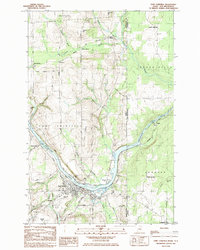
1984 Map of Fort Fairfield
USGS Topo · Published 1985About this map
The Aroostook River curves sharply through the international borderlands, anchoring the regional hub of Fort Fairfield. This 1980s landscape reveals a complex network of transportation and rural community life, where the Bangor and Aroostook and Canadian Pacific railroads converge near the riverbank. The town center is densely detailed, featuring the Municipal Airport, the Armory, and local education landmarks like the High Sch and Middle Sch. Surrounding the town, family-named landmarks and small settlements such as Houghtonville and Tinker populate the countryside.
Find a feature on this map
51 named features on this map. Tap any name to fly to it.
Don’t see what you’re looking for? This feature index may not catch every label — zoom into the map to look around manually.
Map Details
Editions of this 1984 Fort Fairfield Map
This is the sole edition of this map. No revisions or reprints were ever made.
Other maps of this area

1930 · Fort Fairfield
USGS Topo · 1:48,000

1933 · Fort Fairfield
USGS Topo · 1:62,500

1936 · Mars Hill
USGS Topo · 1:48,000

1940 · Mars Hill
USGS Topo · 1:62,500

1951 · Mars Hill
USGS Topo · 1:62,500

1951 · Fort Fairfield
USGS Topo · 1:62,500

1953 · Fort Fairfield NW
USGS Topo · 1:24,000
1953 · Limestone
USGS Topo · 1:24,000

1959 · Woodstock
USGS Topo · 1:250,000

1963 · Woodstock
USGS Topo · 1:250,000