
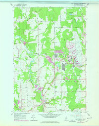
1953 Map of Fort Fairfield NW
USGS Topo · Published 1955About this map
The Loring Air Force Base dominates the eastern landscape of this northern Aroostook County map, its complex infrastructure and housing blocks appearing at a time of significant Cold War expansion. To the west, the rural character of the Maine borderlands remains evident in the winding course of the Little Madawaska River and the small-scale agricultural layout of the Connor and Caswell townships. These communities are anchored by local landmarks such as the Lister Community Ch and Kelly Sch, which served as local social hubs before the full impact of base development transformed the region's economy.
Find a feature on this map
41 named features on this map. Tap any name to fly to it.
Don’t see what you’re looking for? This feature index may not catch every label — zoom into the map to look around manually.
Map Details
Editions of this 1953 Fort Fairfield NW Map
2 editions found
Other maps of this area

1921 · Van Buren
USGS Topo · 1:250,000

1927 · Stockholm
USGS Topo · 1:48,000

1929 · Caribou
USGS Topo · 1:48,000

1930 · Fort Fairfield
USGS Topo · 1:48,000

1931 · Van Buren
USGS Topo · 1:48,000

1931 · Stockholm
USGS Topo · 1:62,500

1932 · Caribou
USGS Topo · 1:62,500

1933 · Fort Fairfield
USGS Topo · 1:62,500

1934 · Van Buren
USGS Topo · 1:62,500

1951 · Van Buren
USGS Topo · 1:62,500