
1936 Map of Mars Hill
USGS Topo · Published 1936About this map
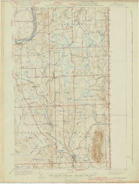
The Bangor and Aroostook RR serves as a primary artery through this productive potato-growing region, connecting small agriculture-centered hubs like Easton, Westfield, and Blaine. The 1930s landscape is densely peppered with dozens of community schoolhouses, from Parkhurst Sch in the north to Silsby Sch near the Canadian border, indicating a highly localized rural population. The topography is dominated by the massive profile of Mars Hill, which rises significantly above the surrounding plains. To the east, the border with Canada is marked with numerous survey monuments. Notable landmarks of early community life include the Friends Ch and Morison Mill near Page Pond, alongside several family-named landmarks like McManus Sch and Gardner Sch. Numerous small lakes and ponds, such as Dilling Lake and Winston Lake, provide drainage for the many brooks feeding into Prestile Stream.
Find a feature on this map
89 named features on this map. Tap any name to fly to it.
Don’t see what you’re looking for? This feature index may not catch every label — zoom into the map to look around manually.
Map Details
Editions of this 1936 Mars Hill Map
This is the sole edition of this map. No revisions or reprints were ever made.
Other maps of this area

1929 · Caribou
USGS Topo · 1:48,000

1930 · Fort Fairfield
USGS Topo · 1:48,000

1932 · Caribou
USGS Topo · 1:62,500

1933 · Fort Fairfield
USGS Topo · 1:62,500

1934 · Bridgewater
USGS Topo · 1:48,000

1935 · Howe Brook
USGS Topo · 1:48,000

1935 · Presque Isle
USGS Topo · 1:62,500

1938 · Bridgewater
USGS Topo · 1:62,500

1939 · Howe Brook
USGS Topo · 1:62,500
1940 · Mars Hill
USGS Topo · 1:62,500