1930s Maps of Hammond, Maine
Explore 6 historic maps of Hammond from the 1930s. These maps offer a rare glimpse into what life looked like during the 1930s — showing old roads, neighborhoods, homes, and landmarks that have changed or disappeared over time.
Whether you're researching your family's past, planning a metal detecting trip, or studying how Hammond's landscape evolved across the 1930s, these high-resolution maps are a powerful tool for exploring the history of this region.
- Focus on a specific era: All maps on this page are from the 1930s, giving you a focused view of this time period.
- See what’s changed: Compare century-old streets, trails, and buildings to today's modern landscape using overlays and satellite layers.
- Research with precision: Use these maps for genealogy, historical research, land use analysis, or educational projects.
- View, download, or print: Maps are fully viewable online in high resolution, and can be downloaded or printed for your own records.
Start exploring Hammond's history through authentic maps from the 1930s. This is your window into the past.
Hammond, ME maps
(6)- 1934 Map of Bridgewater
 1934 Bridgewater1934 Print · USGSAroostook County's border with New Brunswick is detailed here during the mid-1930s, highlighting the Bangor and Aroostook rail network. Genealogists can locate family landmarks like Jewells Corner, Snow Settlement, and Robinson Sta.
 - 1935 Map of Howe Brook
 1935 Howe Brook1935 Print · USGSRemote Aroostook County is shown here in the mid-1930s, when logging camps and the railroad defined the local landscape. Genealogists and researchers can trace the Bangor and Aroostook rail line to find vanished hubs like Little Canada and Weeksboro.
 - 1937 Map of Smyrna Mills
 1937 Smyrna Mills1937 Print · USGSAroostook County's interior is seen here in the 1930s, defined by the timber and rail economy of Smyrna Mills and Oakfield. Researchers can trace the Bangor and Aroostook RR alongside family landmarks like Walker Settlement and the Oakfield Cem.3 unique versions available
 - 1938 Map of Bridgewater
 1938 Bridgewater1938 Print · USGSEastern Aroostook County is shown here during the mid-1930s, documenting the vital rail and border connections of the era. Researchers can trace the old paths of the Bangor and Ar00stook railroad and locate community landmarks like Snow Settlement and Flagstaff Sch.3 unique versions available
 - 1938 Map of Houlton
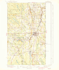 1938 Houlton1938 Print · USGSAroostook County's borderlands are captured here in the late 1930s, showing a landscape of small farming communities and international connections. Researchers can find numerous family-named schoolhouses like Haggerty Sch and trace the rail path of the Canadian Pacific near Littleton Sta.3 unique versions available
 - 1939 Map of Howe Brook
 1939 Howe Brook1939 Print · USGSAroostook County was a hub for timber and rail in the mid-1930s, defined by its remote township grids and wilderness camps. Genealogists and historians can trace old railroad stops at Weeksboro and Saunders or locate early sporting sites like the Mineola Hunting Club.3 unique versions available
End of results
Showing maps 1-6 of 6
Top cities near Hammond
- Houlton historical maps
- Hodgdon historical maps
- Littleton historical maps
- Linneus historical maps
- Island Falls historical maps
- Monticello historical maps
See more
Frequently asked questions
- What are the different types of historical maps available for Hammond?
- What is the oldest map of Hammond?
- Where can I purchase historical maps of Hammond for my home or office?
- Where can I download high-res historical maps of Hammond?
- Are there historical topographic maps available for Hammond?
- Is there historical aerial imagery available for Hammond?
- Where are historical maps of Hammond sourced from?