1980s Maps of Reed Plantation, Maine
Explore 6 historic maps of Reed Plantation from the 1980s. These maps offer a rare glimpse into what life looked like during the 1980s — showing old roads, neighborhoods, homes, and landmarks that have changed or disappeared over time.
Whether you're researching your family's past, planning a metal detecting trip, or studying how Reed Plantation's landscape evolved across the 1980s, these high-resolution maps are a powerful tool for exploring the history of this region.
- Focus on a specific era: All maps on this page are from the 1980s, giving you a focused view of this time period.
- See what’s changed: Compare century-old streets, trails, and buildings to today's modern landscape using overlays and satellite layers.
- Research with precision: Use these maps for genealogy, historical research, land use analysis, or educational projects.
- View, download, or print: Maps are fully viewable online in high resolution, and can be downloaded or printed for your own records.
Start exploring Reed Plantation's history through authentic maps from the 1980s. This is your window into the past.
Reed Plantation, ME maps
(6)- 1985 Map of Millinocket, 1986 Print
 1985 Millinocket1986 Print · USGSThe North Maine Woods were a landscape of industrial timber and wilderness recreation in the mid-eighties. Genealogists and researchers can trace local settlements and rail stops like Sherman Mills, Wytopitlock, and the Old Long A Siding near the Penobscot River.2 unique versions available
 - 1988 Map of Kingman
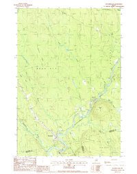
 1988 Kingman1988 Print · USGSPenobscot County, Maine, is shown in the late 1980s as a land of winding waterways and remote plantations. Researchers can trace the riverbanks of the Mattawamkeag River near Kingman or locate landmarks like the Cem and Billy Doe Bog.
 - 1988 Map of Wytopitlock
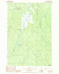
 1988 Wytopitlock1988 Print · USGSThe Mattawamkeag River valley in the late eighties serves as a vital corridor between the small outposts of Wytopitlock and Bancroft. Genealogists and historians can trace the bounds of Reed Plt and Drew Plt while identifying local landmarks like the Mill, Sherwood Mtn, and Palmer Deadwater.
 - 1988 Map of Reed Pond
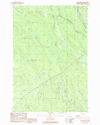
 1988 Reed Pond1988 Print · USGSAroostook County was defined by its timber and stream networks in the late twentieth century. Genealogists and historians can trace the settlement at Reed, locate the Cem, and find historic forest landmarks like the Lookout Tower near Reed Pond.
 - 1989 Map of Alder Brook
 1989 Alder Brook1989 Print · USGSAroostook County's deep woods and river junctions are documented here in the late twentieth century, before modern changes. Genealogists and local historians can locate the Glenwood settlement, the local Cem, and natural landmarks like Codfish Ridge and the Mattawamkeag River.
 - 1989 Map of Wytopitlock Lake
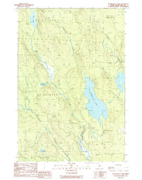 1989 Wytopitlock Lake1989 Print · USGSSouthern Aroostook County is shown in the late eighties as a landscape of timberland tracts and interconnected waterways. Genealogists and outdoor historians can trace the borders of Glenwood Plt, find the local Cem, or follow the course of Wytopitlock Lake.
End of results
Showing maps 1-6 of 6
Top cities near Reed Plantation
- Sherman historical maps
- Mattawamkeag historical maps
- Danforth historical maps
- Winn historical maps
- Amity historical maps
- Weston historical maps
See more
Top neighborhoods of Reed Plantation
Frequently asked questions
- What are the different types of historical maps available for Reed Plantation?
- What is the oldest map of Reed Plantation?
- Where can I purchase historical maps of Reed Plantation for my home or office?
- Where can I download high-res historical maps of Reed Plantation?
- Are there historical topographic maps available for Reed Plantation?
- Is there historical aerial imagery available for Reed Plantation?
- Where are historical maps of Reed Plantation sourced from?