1970s Maps of T11 R7 WELS, Maine
Explore 4 historic maps of T11 R7 WELS from the 1970s. These maps offer a rare glimpse into what life looked like during the 1970s — showing old roads, neighborhoods, homes, and landmarks that have changed or disappeared over time.
Whether you're researching your family's past, planning a metal detecting trip, or studying how T11 R7 WELS's landscape evolved across the 1970s, these high-resolution maps are a powerful tool for exploring the history of this region.
- Focus on a specific era: All maps on this page are from the 1970s, giving you a focused view of this time period.
- See what’s changed: Compare century-old streets, trails, and buildings to today's modern landscape using overlays and satellite layers.
- Research with precision: Use these maps for genealogy, historical research, land use analysis, or educational projects.
- View, download, or print: Maps are fully viewable online in high resolution, and can be downloaded or printed for your own records.
Start exploring T11 R7 WELS's history through authentic maps from the 1970s. This is your window into the past.
T11 R7 WELS, ME maps
(4)- 1975 Map of Greenlaw SW, 1981 Print
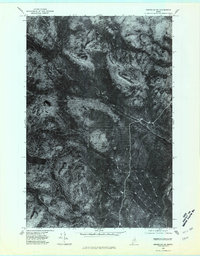 1975 Greenlaw SW1981 Print · USGSAroostook County's deep woods are captured during the mid-seventies in this detailed orthophotograph of the Maine wilderness. Genealogists and researchers can trace the waterways of the Machias River and landmarks like Horse Mountain.
 - 1975 Map of Greenlaw NE, 1981 Print
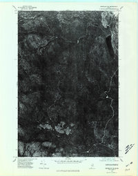 1975 Greenlaw NE1981 Print · USGSThe deep woods of Aroostook County are seen from above in the mid-seventies, showing the Maine wilderness before decades of modern forest management. Trace the untouched shore of Little Machias Lake and the winding course of the Little Machias River.
 - 1975 Map of Greenlaw NW, 1981 Print
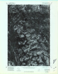 1975 Greenlaw NW1981 Print · USGSUpper Aroostook County timberlands are captured in this mid-seventies aerial survey, showing the deep woods before the era of digital mapping. Researchers can trace the path of the Machias River and locate landmarks like Greenlaw Pond and Bald Mountain.
 - 1975 Map of Greenlaw SE, 1981 Print
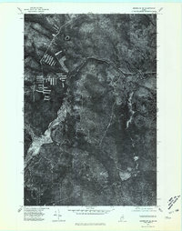 1975 Greenlaw SE1981 Print · USGSLogging operations and watercourses define this section of the Maine woods in the mid-seventies. Trace the winding path of the Machias River and the isolated drainage of Greenlaw Stream through dense timberland and recent clearings.
End of results
Showing maps 1-4 of 4
Top cities near T11 R7 WELS
- Ashland historical maps
- Portage Lake historical maps
- Masardis historical maps
- Garfield Plantation historical maps
- Oxbow historical maps
- Nashville Plantation historical maps
Top neighborhoods of T11 R7 WELS
Frequently asked questions
- What are the different types of historical maps available for T11 R7 WELS?
- What is the oldest map of T11 R7 WELS?
- Where can I purchase historical maps of T11 R7 WELS for my home or office?
- Where can I download high-res historical maps of T11 R7 WELS?
- Are there historical topographic maps available for T11 R7 WELS?
- Is there historical aerial imagery available for T11 R7 WELS?
- Where are historical maps of T11 R7 WELS sourced from?