1980s Maps of T12 R8 WELS, Maine
Explore 4 historic maps of T12 R8 WELS from the 1980s. These maps offer a rare glimpse into what life looked like during the 1980s — showing old roads, neighborhoods, homes, and landmarks that have changed or disappeared over time.
Whether you're researching your family's past, planning a metal detecting trip, or studying how T12 R8 WELS's landscape evolved across the 1980s, these high-resolution maps are a powerful tool for exploring the history of this region.
- Focus on a specific era: All maps on this page are from the 1980s, giving you a focused view of this time period.
- See what’s changed: Compare century-old streets, trails, and buildings to today's modern landscape using overlays and satellite layers.
- Research with precision: Use these maps for genealogy, historical research, land use analysis, or educational projects.
- View, download, or print: Maps are fully viewable online in high resolution, and can be downloaded or printed for your own records.
Start exploring T12 R8 WELS's history through authentic maps from the 1980s. This is your window into the past.
T12 R8 WELS, ME maps
(4)- 1985 Map of Carr Pond, 1986 Print
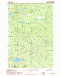 1985 Carr Pond1986 Print · USGSThe remote Aroostook County backcountry of the mid-1980s is captured here, showing a landscape defined by timber roads and glacial waters. Local historians can trace early access points like High Landing or locate remote camps near Carr Pond and Fish River Lake.
 - 1985 Map of Fish River Lake, 1986 Print
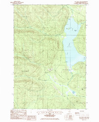 1985 Fish River Lake1986 Print · USGSAroostook County's North Woods are captured here in the mid-1980s, showcasing a landscape of timber management and seasonal sporting camps. Researchers can trace the remote shoreline of Fish River Lake to find Moose Point Camps and Zella Island.
 - 1985 Map of Big Machias Lake, 1986 Print
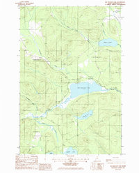 1985 Big Machias Lake1986 Print · USGSAroostook County's deep woods and timberlands are captured here in the mid-eighties, showing a landscape defined by industrial forestry and vast lake systems. Researchers can trace the flow of the Machias River and locate remote landmarks like Bishop Mountain and Billings Pond.
 - 1986 Map of Greenlaw Pond
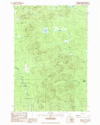 1986 Greenlaw Pond1986 Print · USGSThe Aroostook County backcountry in the mid-1980s is a landscape of township blocks and timber tracts. Researchers can trace the river economy through Russell Crossing, Greenlaw Crossing, and the remote Gravel Pit near Greenlaw Stream.
End of results
Showing maps 1-4 of 4
Top cities near T12 R8 WELS
- Portage Lake historical maps
- Winterville Plantation historical maps
- Garfield Plantation historical maps
- Nashville Plantation historical maps
Frequently asked questions
- What are the different types of historical maps available for T12 R8 WELS?
- What is the oldest map of T12 R8 WELS?
- Where can I purchase historical maps of T12 R8 WELS for my home or office?
- Where can I download high-res historical maps of T12 R8 WELS?
- Are there historical topographic maps available for T12 R8 WELS?
- Is there historical aerial imagery available for T12 R8 WELS?
- Where are historical maps of T12 R8 WELS sourced from?