1950s Maps of T15 R12 WELS, Maine
Explore 5 historic maps of T15 R12 WELS from the 1950s. These maps offer a rare glimpse into what life looked like during the 1950s — showing old roads, neighborhoods, homes, and landmarks that have changed or disappeared over time.
Whether you're researching your family's past, planning a metal detecting trip, or studying how T15 R12 WELS's landscape evolved across the 1950s, these high-resolution maps are a powerful tool for exploring the history of this region.
- Focus on a specific era: All maps on this page are from the 1950s, giving you a focused view of this time period.
- See what’s changed: Compare century-old streets, trails, and buildings to today's modern landscape using overlays and satellite layers.
- Research with precision: Use these maps for genealogy, historical research, land use analysis, or educational projects.
- View, download, or print: Maps are fully viewable online in high resolution, and can be downloaded or printed for your own records.
Start exploring T15 R12 WELS's history through authentic maps from the 1950s. This is your window into the past.
T15 R12 WELS, ME maps
(5)- 1954 Map of Presque Isle, 1968 Print
 1954 Presque Isle1968 Print · USGSNorth Woods logging and rail history come alive in this mid-century survey of the Maine-Quebec borderlands. Genealogists and historians can trace the Bangor and Aroostook railroad through timber hubs like Ashland, Smyrna Mills, and Presque Isle.2 unique versions available
 - 1955 Map of Rocky Mountain
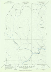 1955 Rocky Mountain1955 Print · USGSThe Aroostook County wilderness in the mid-1950s is defined here by the winding St John River and the international boundary with Canada. Researchers can locate logging outposts like Campbell Depot Camp and riverside landmarks such as Schoolhouse Rapids and Ouellette Farm.3 unique versions available
 - 1955 Map of Round Pond, 1956 Print
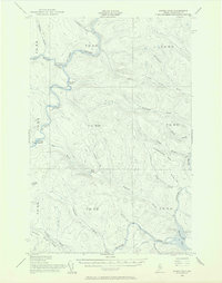 1955 Round Pond1956 Print · USGSNorthern Maine's remote borderlands and river corridors are charted here in the mid-fifties, before modern development. You can trace early wilderness outposts like the Immigration Service Camp, find the Game Warden Camp on Round Pond, and locate landmarks like Big Black Rapids.5 unique versions available
 - 1956 Map of Allagash Falls
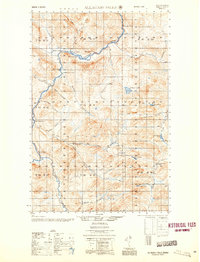 1956 Allagash Falls1956 Print · USGSThe Maine North Woods in the mid-fifties remain a world of logging camps and remote river outposts along the Allagash. Trace the legacy of river driving and timber harvesting through sites like Cunliffe Depot Camp, Michaud Farm, and the iconic Allagash Falls.2 unique versions available
 - 1958 Map of Presque Isle
 1958 Presque Isle1958 Print · USGSThe Aroostook timber and potato country is captured here during the late fifties, showing the vital rail-to-river network of Northern Maine. Genealogists and historians can trace the Bangor & Aroostook RR through Mapleton and Ashland, or locate remote sites like Chamberlain Farm and Seven Islands.
End of results
Showing maps 1-5 of 5
Top cities near T15 R12 WELS
Frequently asked questions
- What are the different types of historical maps available for T15 R12 WELS?
- What is the oldest map of T15 R12 WELS?
- Where can I purchase historical maps of T15 R12 WELS for my home or office?
- Where can I download high-res historical maps of T15 R12 WELS?
- Are there historical topographic maps available for T15 R12 WELS?
- Is there historical aerial imagery available for T15 R12 WELS?
- Where are historical maps of T15 R12 WELS sourced from?