1980s Maps of T15 R12 WELS, Maine
Explore 4 historic maps of T15 R12 WELS from the 1980s. These maps offer a rare glimpse into what life looked like during the 1980s — showing old roads, neighborhoods, homes, and landmarks that have changed or disappeared over time.
Whether you're researching your family's past, planning a metal detecting trip, or studying how T15 R12 WELS's landscape evolved across the 1980s, these high-resolution maps are a powerful tool for exploring the history of this region.
- Focus on a specific era: All maps on this page are from the 1980s, giving you a focused view of this time period.
- See what’s changed: Compare century-old streets, trails, and buildings to today's modern landscape using overlays and satellite layers.
- Research with precision: Use these maps for genealogy, historical research, land use analysis, or educational projects.
- View, download, or print: Maps are fully viewable online in high resolution, and can be downloaded or printed for your own records.
Start exploring T15 R12 WELS's history through authentic maps from the 1980s. This is your window into the past.
T15 R12 WELS, ME maps
(4)- 1986 Map of Mc Kinnon Brook
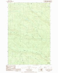 1986 Mc Kinnon Brook1986 Print · USGSNorthern Maine's timberlands are captured in the mid-eighties, showing the structured wilderness of Aroostook County. Trace the remote waterways of the Allagash Wilderness State Waterway and landmarks like McKinnon Brook or the local Shale Pit.
 - 1986 Map of Allagash Falls
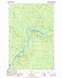 1986 Allagash Falls1986 Print · USGSThe northern Maine woods are captured here in the mid-1980s, centered on the protected waters of the Allagash Wilderness State Waterway. You can trace the river's path through landmarks like Allagash Falls, Michaud Farm, and the Pelletier Deadwater Islands.
 - 1986 Map of Big Rapids, 1987 Print
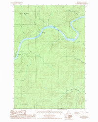 1986 Big Rapids1987 Print · USGSThe North Maine Woods in the mid-eighties reveal a landscape of timberlands and river navigation along the St John River. Outdoorsmen and researchers can trace the river's course through Big Rapids and locate isolated landmarks like the Clay Pit and Poplar Island.
 - 1987 Map of Schoolhouse Rapids
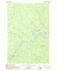 1987 Schoolhouse Rapids1987 Print · USGSIn the remote northern Maine wilderness during the late eighties, the St John River remains the central artery for movement and survival. Researchers can locate historic clearings like Castonia Farm and trace river hazards like Schoolhouse Rapids and Longs Rapids.
End of results
Showing maps 1-4 of 4
Top cities near T15 R12 WELS
Frequently asked questions
- What are the different types of historical maps available for T15 R12 WELS?
- What is the oldest map of T15 R12 WELS?
- Where can I purchase historical maps of T15 R12 WELS for my home or office?
- Where can I download high-res historical maps of T15 R12 WELS?
- Are there historical topographic maps available for T15 R12 WELS?
- Is there historical aerial imagery available for T15 R12 WELS?
- Where are historical maps of T15 R12 WELS sourced from?