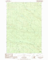
1986 Map of Mc Kinnon Brook
USGS Topo · Published 1986About this map
The Allagash Wilderness State Waterway marks the southeastern edge of this terrain, where the northern Maine woods are defined by an intricate network of drainage basins. Named waterways like McKinnon Brook and Ben Glazier Brook flow through the township subdivisions of T 15 R 13 W E L S and T 14 R 12 W E L S, illustrating the structured land management typical of Aroostook County's timberlands. A lone Shale Pit and a marked Private Rd suggest the industrial presence of logging and resource extraction in an otherwise uninhabited landscape. The topography is dominated by the catchments for Stewart Brook and the West Branch, which feed into the larger regional river systems. This 1980s survey reflects a period of modern wilderness conservation and active forest management, documenting the precise locations of small tributaries like Farm Bk and Savage Brook before they reach the Bogan Brook wetlands.
Find a feature on this map
15 named features on this map. Tap any name to fly to it.
Don’t see what you’re looking for? This feature index may not catch every label — zoom into the map to look around manually.
Map Details
Editions of this 1986 Mc Kinnon Brook Map
This is the sole edition of this map. No revisions or reprints were ever made.
Other maps of this area

1930 · Allagash
USGS Topo · 1:48,000

1932 · Allagash Falls
USGS Topo · 1:48,000

1933 · Allagash
USGS Topo · 1:62,500

1935 · Allagash Falls
USGS Topo · 1:62,500

1954 · Presque Isle
USGS Topo · 1:250,000

1955 · Rocky Mountain
USGS Topo · 1:62,500

1955 · Round Pond
USGS Topo · 1:62,500

1956 · Allagash Falls
USGS Topo · 1:50,000

1958 · Presque Isle
USGS Topo · 1:250,000

1960 · Presque Isle
USGS Topo · 1:250,000