1980s Maps of T15 R8 WELS, Maine
Explore 4 historic maps of T15 R8 WELS from the 1980s. These maps offer a rare glimpse into what life looked like during the 1980s — showing old roads, neighborhoods, homes, and landmarks that have changed or disappeared over time.
Whether you're researching your family's past, planning a metal detecting trip, or studying how T15 R8 WELS's landscape evolved across the 1980s, these high-resolution maps are a powerful tool for exploring the history of this region.
- Focus on a specific era: All maps on this page are from the 1980s, giving you a focused view of this time period.
- See what’s changed: Compare century-old streets, trails, and buildings to today's modern landscape using overlays and satellite layers.
- Research with precision: Use these maps for genealogy, historical research, land use analysis, or educational projects.
- View, download, or print: Maps are fully viewable online in high resolution, and can be downloaded or printed for your own records.
Start exploring T15 R8 WELS's history through authentic maps from the 1980s. This is your window into the past.
T15 R8 WELS, ME maps
(4)- 1985 Map of Island Pond, 1986 Print
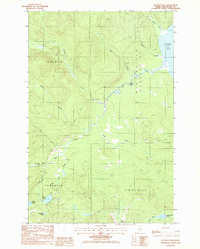 1985 Island Pond1986 Print · USGSThe North Maine Woods are captured in the mid-1980s, showing a landscape of timber tracts and river systems. You can trace logging history through a network of Private Roads and Gravel Pits near St Froid Lake and Island Pond.
 - 1985 Map of Mc Lean Mtn, 1986 Print
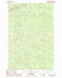 1985 Mc Lean Mtn1986 Print · USGSThe northern Maine woods of the mid-1980s appear here as a complex network of timber roads and mountain watersheds. Outdoor enthusiasts and local historians can trace the headwaters of the North Branch Birch River or locate remote landmarks like McLean Lake and Horseshoe Pond.
 - 1985 Map of Wallagrass Lakes, 1986 Print
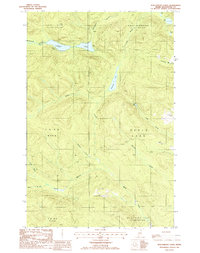 1985 Wallagrass Lakes1986 Print · USGSNorthern Maine's lake country is captured in the mid-1980s when timber and water dominated the landscape of the northern townships. Researchers can trace the drainage patterns of Wallagrass Lakes and identify early land divisions in St John Plantation and Winterville Plantation.
 - 1985 Map of Deboullie Pond, 1986 Print
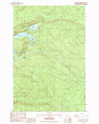 1985 Deboullie Pond1986 Print · USGSThe northern Maine woods come into focus in the mid-1980s, showcasing a landscape of high-elevation ponds and sporting camps. Trace the locations of Red River Camps, the Lookout Tower on Black Mountain, and remote waters like Deboullie Pond.
End of results
Showing maps 1-4 of 4
Top cities near T15 R8 WELS
- Eagle Lake historical maps
- Wallagrass historical maps
- Saint Francis historical maps
- Portage Lake historical maps
- New Canada historical maps
- Saint John Plantation historical maps
See more
Frequently asked questions
- What are the different types of historical maps available for T15 R8 WELS?
- What is the oldest map of T15 R8 WELS?
- Where can I purchase historical maps of T15 R8 WELS for my home or office?
- Where can I download high-res historical maps of T15 R8 WELS?
- Are there historical topographic maps available for T15 R8 WELS?
- Is there historical aerial imagery available for T15 R8 WELS?
- Where are historical maps of T15 R8 WELS sourced from?