Old Maps of Dry Mills, Gray for Genealogy
Trace your family roots with 16 historic maps of Dry Mills. These high-res maps reveal old neighborhoods, homesites, landmarks, and streets — helping you uncover where your ancestors lived and how the area evolved over time.
- Explore historic neighborhoods: Identify where your relatives may have lived in the 1800s or 1900s.
- Compare maps over time: Trace the changes in streets, buildings, and landmarks for multi-generational research.
- Perfect for genealogy & ancestry research: Used by family historians and researchers to map out lineage and migration.
These maps are an incredible resource for exploring your personal connection to Dry Mills's past.
Dry Mills, Gray maps
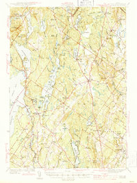
(16)- 1894 Map of Gray
 1894 Gray1894 Print · USGSMaine's Sebago Lake region at the close of the nineteenth century shows a network of mill towns and early rail lines. Trace family roots and vanished landmarks through New Gloucester, Sabbathday Lake, and the depots along the Maine Central R. R.
 - 1898 Map of Gray
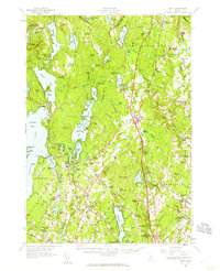
 1898 Gray1898 Print · USGSIn the 1890s, this area of southern Maine was a landscape of evolving rail connections and traditional mill towns. Genealogists can trace family roots through settlements like New Gloucester and Cumberland Center, or locate early landmarks such as Webbs Mills and Sabbathday Lake.7 unique versions available
 - 1942 Map of Gray, 1956 Print
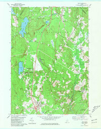
 1942 Gray1956 Print · USGSCumberland County’s interior landscape comes into focus during the early 1940s, revealing a network of rail-side stations and crossroads hamlets. Genealogists and historians can trace family locations near Suckerville, Purinton Cem, and the Friends Ch.
 - 1944 Map of Gray
 1944 Gray1944 Print · USGSCumberland County village life and the rail-and-water economy are captured here just after the war. You can trace the Maine Central line through several depots or locate historic family landmarks like Purinton Cem and the Opportunity Sch.3 unique versions available
 - 1949 Map of Portland
 1949 Portland1949 Print · USGSCoastal Maine and the New Hampshire interior are shown in detail during the late forties, from the bustling harbors to the lakeside villages. Researchers can trace historical rail networks like the Boston & Maine RR and locate coastal defenses such as Fort Preble.3 unique versions available
 - 1956 Map of Portland, 1963 Print
 1956 Portland1963 Print · USGSSouthern Maine and eastern New Hampshire are captured here in the mid-fifties, during a time of major highway expansion and military growth. You can trace the path of the Maine Turnpike and locate landmarks like the Portsmouth Naval Shipyard and Sebago Lake.4 unique versions available
 - 1957 Map of Gray, 1960 Print
 1957 Gray1960 Print · USGSCumberland County during the mid-fifties shows a landscape of established rail towns and growing turnpike access. Genealogists and historians can trace family locations near crossroads like Ireland Corner, find old schools such as Gloucester Hill School, and locate rural landmarks like Windham Plains Chapel.5 unique versions available
 - 1959 Map of Portland
 1959 Portland1959 Print · USGSThe Maine and New Hampshire coastlines meet in this mid-century portrait of maritime commerce and inland rail networks. Researchers can trace the legacy of coastal defense at Fort Williams and follow the historic path of the Maine Central RR through the White Mountain National Forest.2 unique versions available
 - 1963 Map of Portland
 1963 Portland1963 Print · USGSCoastal Maine and New Hampshire thrived as maritime and industrial hubs during the mid-sixties, linked by a dense network of rail and river. Researchers can trace historic transit corridors like the Maine Central RR and locate key sites such as the Portsmouth Naval Shipyard or Pease Air Force Base.3 unique versions available
 - 1980 Map of Gray, 1981 Print
 1980 Gray1981 Print · USGSThe Gray and New Gloucester area in the early eighties shows a transition from rural landscape to modern thoroughfare. Researchers can trace the layout of Shaker Village, the Pineland Hospital and Training Center, and old rail stops at Intervale.3 unique versions available
 - 1985 Map of Portland, 1986 Print
 1985 Portland1986 Print · USGSThe Maine coast and Sebago Lake region are captured in the mid-1980s, showcasing the transition from traditional maritime centers to a modern transportation hub. Genealogists and historians can trace rail lines like the Grand Trunk RR and find local landmarks such as the U.S. Marine Hospital or Old Orchard Beach.2 unique versions available
 - 2011 Map of Gray, 2011 Print
 2011 Gray2011 Print · USGSCovers Dry Mills, including Auburn, Gray, and other nearby areas
 - 2014 Map of Gray, 2014 Print
 2014 Gray2014 Print · USGSCovers Dry Mills, including Auburn, Gray, and other nearby areas
 - 2018 Map of Gray, 2018 Print
 2018 Gray2018 Print · USGSCovers Dry Mills, including Auburn, Gray, and other nearby areas
 - 2021 Map of Gray, 2021 Print
 2021 Gray2021 Print · USGSCovers Dry Mills, including Auburn, Gray, and other nearby areas
 - 2024 Map of Gray, 2024 Print
 2024 Gray2024 Print · USGSThe rural stretches of Cumberland County are shown here in the 2020s, centered on the crossroads of Gray Village and the historic Shaker Village. Genealogists and local historians can trace family plots at Lower Corner Cem and explore the surroundings of Sabbathday Pond and Crystal Lake.
End of results
Showing maps 1-16 of 16
Frequently asked questions
- What are the different types of historical maps available for Dry Mills?
- What is the oldest map of Dry Mills?
- Where can I purchase historical maps of Dry Mills for my home or office?
- Where can I download high-res historical maps of Dry Mills?
- Are there historical topographic maps available for Dry Mills?
- Is there historical aerial imagery available for Dry Mills?
- Where are historical maps of Dry Mills sourced from?