Old Maps of Carthage, Maine for Academic Research
Study the evolution of Carthage with 48 high-resolution historic maps. Whether you're teaching, researching, or modeling changes in land use, these maps provide essential visual documentation of urban, environmental, and geographic change.
- Analyze long-term change: Track patterns in development, transportation, and natural features.
- Ideal for environmental or urban studies: Support academic projects with primary historical map data.
- Use in the classroom or lab: Educators and researchers rely on these maps to bring historical context to life.
These maps are a powerful tool for teaching, research, and visualizing how Carthage has changed over the decades.
Carthage, ME maps
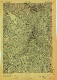
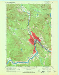
(48)- 1926 Map of Dixfield, 1953 Print
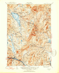 1926 Dixfield1953 Print · USGSWestern Maine's river valleys and highlands are captured here in the mid-twenties, showcasing the region's rail and timber economy. Genealogists can trace family schoolhouses like Maple Grove Sch or locate old mill sites such as Hildreths Mill near Lake Webb.2 unique versions available
 - 1927 Map of Rumford
 1927 Rumford1927 Print · USGSOxford County at the end of the twenties shows a landscape of river-valley industry and upland homesteads. Genealogists can trace family school districts like Red Hill Sch and North Rumford Sch or find the Stockbridge Cem near the Garland settlement.3 unique versions available
 - 1929 Map of Dixfield
 1929 Dixfield1929 Print · USGSFranklin and Oxford Counties are captured here in the late twenties, showing the transition from mountain peaks to river valley commerce. Genealogists and historians can trace district schools and old farmstead locations from Weld Corner Sch. down to the Maine Central rail lines at Dixfield.5 unique versions available
 - 1930 Map of Rumford
 1930 Rumford1930 Print · USGSRumford and the Androscoggin River valley are shown here just before the Great Depression, highlighting a bustling landscape of rail and industry. Genealogists and historians can trace local families through many district schools like Woodrow Sch and landmarks like Stockbridge Cem or Rumford Falls.5 unique versions available
 - 1950 Map of Lewiston
 1950 Lewiston1950 Print · USGSThe Maine and New Hampshire borderlands come alive in this post-war survey of the White Mountains and Androscoggin valley. Genealogists and historians can trace rail lines like the Maine Central Railroad and find high-altitude landmarks from Mount Washington to Bretton Woods.2 unique versions available
 - 1956 Map of Dixfield, 1958 Print
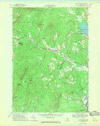
 1956 Dixfield1958 Print · USGSIn the mid-1950s, the western Maine landscape centered on the bustling river town of Dixfield and the expanses of Mt Blue State Park. Genealogists and historians can trace family cemeteries like Birchland Cem and old industrial sites like Hildreths Mill.5 unique versions available
 - 1956 Map of Lewiston, 1975 Print
 1956 Lewiston1975 Print · USGSThe Northern New England interior is documented here in the mid-fifties, from the industrial Androscoggin River to the high peaks of the White Mountains. Trace the Grand Trunk Railway through mountain passes or locate family landmarks near Sabbathday Lake and Bretton Woods.
 - 1961 Map of Lewiston
 1961 Lewiston1961 Print · USGSWestern Maine and the White Mountains appear here during the early sixties, showing the industrial river towns and vast timberlands before the modern interstate era. Genealogists and historians can trace the Grand Trunk RR through Berlin or locate landmarks like Old Speck Mountain and Elephant Mountain.
 - 1962 Map of Lewiston
 1962 Lewiston1962 Print · USGSThe industrial river valleys and high peaks of Maine and New Hampshire define the region in the early sixties. Trace the rail-and-river network from Lewiston to the White Mountains, passing through mill towns like Berlin and Rumford.
 - 1968 Map of Mount Blue, 1970 Print
 1968 Mount Blue1970 Print · USGSFranklin County's high country and wooded plantations are captured here in the late sixties, showcasing the high-elevation terrain of Mount Blue State Park. Genealogists and local historians can trace family-named sites like Hildreths Mill, Staples Cem, and the small settlement at Temple Intervale.2 unique versions available
 - 1968 Map of East Dixfield, 1970 Print
 1968 East Dixfield1970 Print · USGSWestern Maine highlands meet the river valleys in the late sixties, showcasing the rural landscapes of Franklin and Oxford Counties. Genealogists can locate family landmarks like Science Hill Cemetery, Walker Hill, and the community of East Dixfield.2 unique versions available
 - 1968 Map of Weld, 1970 Print
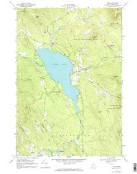 1968 Weld1970 Print · USGSIn the late sixties, the Highlands of Franklin County remained a landscape of mountain ridges and secluded lakefronts. Researchers can trace family sites at Mountain View Cemetery or follow the small-town roots of Berry Mills and Carthage along the Webb River.3 unique versions available
 - 1968 Map of Dixfield, 1971 Print
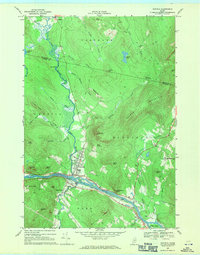 1968 Dixfield1971 Print · USGSOxford County communities like Dixfield and Peru are shown at their industrial and agricultural peak in the late sixties. Researchers can trace the Maine Central rail line or locate family plots at Riverside Cem and Waite Cem.2 unique versions available
 - 1969 Map of Lewiston
 1969 Lewiston1969 Print · USGSThe northern New England highlands come into focus during the mid-fifties, showing the vital rail and river networks connecting industrial centers to the deep woods. Researchers can trace the path of the Grand Trunk RR or locate landmarks like Mt Washington and Rangeley Lake.
 - 1969 Map of Roxbury, 1972 Print
 1969 Roxbury1972 Print · USGSRoxbury and the Swift River valley are shown in detail during the late sixties as they transition between the peaks of Oxford and Franklin Counties. Researchers can locate Pineview Cem, trace the historic WALKER TRAIL, and identify old family farm landmarks like Thomas Farm Brook.
 - 1969 Map of Rumford, 1972 Print
 1969 Rumford1972 Print · USGSOxford County industrial life and rural landscapes meet in the late sixties at the junction of the Androscoggin River and Swift River. Researchers can trace the town layout of Rumford and Mexico, finding family cemeteries like Bisbee Cem and historic sites such as the Rumford Falls Powerplant.2 unique versions available
 - 1986 Map of Rumford
 1986 Rumford1986 Print · USGSWestern Maine in the mid-eighties shows a rugged landscape of industrial river towns and high-country timber plantations. Trace the rail-and-river economy through Rumford, Dixfield, and the Maine Central RR or locate the historic campus of Farmington State College.
 - 1994 Map of Rumford
 1994 Rumford1994 Print · USGSWestern Maine's mountains and glacial lakes are shown here in the mid-1990s, from the peaks of the Mahoosuc Range to the banks of the Androscoggin River. Trace the Maine Central RR through Dixfield or locate lakeside settlements like Oquossoc.
 - 2011 Map of Rumford, 2011 Print
 2011 Rumford2011 Print · USGSCovers Carthage, including Rumford, Mexico, and other nearby areas
 - 2011 Map of Weld, 2011 Print
 2011 Weld2011 Print · USGSCovers Carthage, including Weld, Township 6 North of Weld, and other nearby areas
 - 2011 Map of Mount Blue, 2011 Print
 2011 Mount Blue2011 Print · USGSCovers Carthage, including Wilton, Temple, and other nearby areas
 - 2011 Map of Dixfield, 2011 Print
 2011 Dixfield2011 Print · USGSCovers Carthage, including Rumford, Mexico, and other nearby areas
 - 2011 Map of Roxbury, 2011 Print
 2011 Roxbury2011 Print · USGSCovers Carthage, including Weld, Roxbury, and other nearby areas
 - 2011 Map of East Dixfield, 2011 Print
 2011 East Dixfield2011 Print · USGSCovers Carthage, including Jay, Wilton, and other nearby areas
 - 2014 Map of Roxbury, 2014 Print
 2014 Roxbury2014 Print · USGSCovers Carthage, including Weld, Roxbury, and other nearby areas
Showing maps 1-25 of 48
Top cities near Carthage
- Farmington historical maps
- Jay historical maps
- Rumford historical maps
- Wilton historical maps
- Mexico historical maps
- Bethel historical maps
See more
Top neighborhoods of Carthage
Frequently asked questions
- What are the different types of historical maps available for Carthage?
- What is the oldest map of Carthage?
- Where can I purchase historical maps of Carthage for my home or office?
- Where can I download high-res historical maps of Carthage?
- Are there historical topographic maps available for Carthage?
- Is there historical aerial imagery available for Carthage?
- Where are historical maps of Carthage sourced from?