1970s Maps of Freeman Township, Maine
Explore 4 historic maps of Freeman Township from the 1970s. These maps offer a rare glimpse into what life looked like during the 1970s — showing old roads, neighborhoods, homes, and landmarks that have changed or disappeared over time.
Whether you're researching your family's past, planning a metal detecting trip, or studying how Freeman Township's landscape evolved across the 1970s, these high-resolution maps are a powerful tool for exploring the history of this region.
- Focus on a specific era: All maps on this page are from the 1970s, giving you a focused view of this time period.
- See what’s changed: Compare century-old streets, trails, and buildings to today's modern landscape using overlays and satellite layers.
- Research with precision: Use these maps for genealogy, historical research, land use analysis, or educational projects.
- View, download, or print: Maps are fully viewable online in high resolution, and can be downloaded or printed for your own records.
Start exploring Freeman Township's history through authentic maps from the 1970s. This is your window into the past.
Freeman Township, ME maps
(4)- 1977 Map of Mount Abraham, 1983 Print
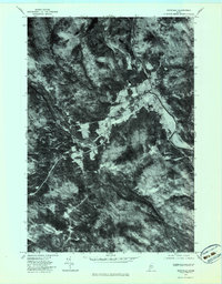
 1977 Mount Abraham1983 Print · USGSThe Franklin County highlands are captured in late autumn during the late seventies, showing the rugged timberlands of the western mountains. Trace the footprints of Salem and Barnjum or follow the paths of Rapid Stream and Quick Stream.
 - 1977 Map of Phillips, 1983 Print
 1977 Phillips1983 Print · USGSFranklin County in the late 1970s is shown here as a landscape of river valleys and mountain peaks centered on the Phillips area. Researchers can trace the winding course of the Sandy River and locate rural landmarks like Avon Corner and Mount Blue Pond.
 - 1977 Map of Kingfield, 1983 Print
 1977 Kingfield1983 Print · USGSMaine's timber country is captured in the late seventies as the town of Kingfield sits at the fork of the Carrabassett River. Researchers can trace the footprints of industry at Soule Mill and follow the paths of Luce Brook.
 - 1977 Map of Strong, 1983 Print
 1977 Strong1983 Print · USGSFranklin County's river valley and timberlands are captured in the late 1970s as agricultural fields still line the Sandy River. Genealogists and local researchers can trace the precise building footprints and rural roads connecting Strong, South Strong, and Gammon Pond.
End of results
Showing maps 1-4 of 4
Top cities near Freeman Township
- Farmington historical maps
- Wilton historical maps
- Anson historical maps
- New Sharon historical maps
- Strong historical maps
- Kingfield historical maps
See more
Frequently asked questions
- What are the different types of historical maps available for Freeman Township?
- What is the oldest map of Freeman Township?
- Where can I purchase historical maps of Freeman Township for my home or office?
- Where can I download high-res historical maps of Freeman Township?
- Are there historical topographic maps available for Freeman Township?
- Is there historical aerial imagery available for Freeman Township?
- Where are historical maps of Freeman Township sourced from?