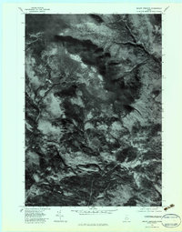
1977 Map of Mount Abraham
USGS Topo · Published 1983About this map
Mount Abraham dominates the high terrain of this 1977 orthophotoquad, showing the Franklin County landscape as it appeared in late October. The aerial imagery captures a transition in the valley floor near the settlements of Barnjum and Salem, where the drainage network of Rapid Stream and Quick Stream feeds into the larger West Branch Carrabassett River. Because this is an orthophotomap rather than a traditional line-and-symbol topo, it reveals the actual patterns of timber harvesting and forest cover that defined the region's economy in the late seventies. Researchers can observe the exact footprint of small settlements and the winding paths of logging roads carved into the slopes of the massif, providing a precise visual record of land use before subsequent decades of regrowth and development.
Find a feature on this map
6 named features on this map. Tap any name to fly to it.
Don’t see what you’re looking for? This feature index may not catch every label — zoom into the map to look around manually.
Map Details
Editions of this 1977 Mount Abraham Map
This is the sole edition of this map. No revisions or reprints were ever made.
Other maps of this area

1928 · Dead River
USGS Topo · 1:62,500

1928 · Stratton
USGS Topo · 1:48,000

1929 · Phillips
USGS Topo · 1:48,000

1930 · Kingfield
USGS Topo · 1:48,000

1931 · Dead River
USGS Topo · 1:48,000

1932 · Phillips
USGS Topo · 1:62,500

1932 · Stratton
USGS Topo · 1:62,500

1932 · Kingfield
USGS Topo · 1:62,500

1944 · Dead River
USGS Topo · 1:62,500

1949 · Jackman
USGS Topo · 1:250,000