1970s Maps of Kibby Township, Maine
Explore 9 historic maps of Kibby Township from the 1970s. These maps offer a rare glimpse into what life looked like during the 1970s — showing old roads, neighborhoods, homes, and landmarks that have changed or disappeared over time.
Whether you're researching your family's past, planning a metal detecting trip, or studying how Kibby Township's landscape evolved across the 1970s, these high-resolution maps are a powerful tool for exploring the history of this region.
- Focus on a specific era: All maps on this page are from the 1970s, giving you a focused view of this time period.
- See what’s changed: Compare century-old streets, trails, and buildings to today's modern landscape using overlays and satellite layers.
- Research with precision: Use these maps for genealogy, historical research, land use analysis, or educational projects.
- View, download, or print: Maps are fully viewable online in high resolution, and can be downloaded or printed for your own records.
Start exploring Kibby Township's history through authentic maps from the 1970s. This is your window into the past.
Kibby Township, ME maps
(9)- 1970 Map of Merrill Mountain, 1973 Print
 1970 Merrill Mountain1973 Print · USGSThe international border between Maine and Quebec was surveyed here in the early 1970s, revealing a landscape of timberlands and isolated outposts. Researchers can trace historic township lines like the Merrill Strip and find remote sites such as Moose Mill Camp and Lower Nathan Bog.
 - 1970 Map of Kibby Mountain, 1973 Print
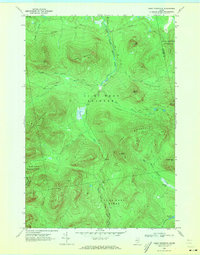 1970 Kibby Mountain1973 Print · USGSThe Maine highlands and timberlands of Franklin County are shown here in the early seventies, centered on the heights of Kibby Mountain. Researchers can trace the mid-century logging roads and remote water bodies like Caribou Pond and Spencer Bog.2 unique versions available
 - 1976 Map of Sherbrooke
 1976 Sherbrooke1976 Print · USGSThe northern Maine woods and Quebec’s Eastern Townships meet in this mid-century survey of the rugged international borderlands. Genealogists and historians can trace rail-and-river connections through Thetford Mines, follow the Dead River to Flagstaff Lake, or locate small border crossings at Stanhope and Beecher Falls.2 unique versions available
 - 1977 Map of Tumbledown Mountain, 1983 Print
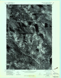 1977 Tumbledown Mountain1983 Print · USGSSomerset County's timberlands are captured in detail during the late 1970s through this orthophoto survey. Researchers can trace the water systems of Baker Stream and Spencer Stream or locate remote landmarks like Rock Pond.
 - 1977 Map of Chain Of Ponds, 1983 Print
 1977 Chain Of Ponds1983 Print · USGSThe Maine wilderness in the late seventies is captured here through detailed aerial imagery, focusing on the deep waters of the Chain of Ponds. Researchers can trace the isolated Upper Farm and the high-elevation peaks of Snow Mountain and Bag Pond Mountain.
 - 1977 Map of Jim Pond, 1983 Print
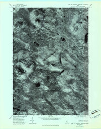
 1977 Jim Pond1983 Print · USGSFranklin County's remote wilderness is captured in the late seventies through this detailed aerial orthophotograph. Researchers can trace the winding course of the Dead River and study the terrain surrounding Kibby Range and Jim Pond.
 - 1977 Map of Merrill Mountain, 1983 Print
 1977 Merrill Mountain1983 Print · USGSThe Maine-Quebec border region is shown in high detail through 1970s aerial imagery, revealing the untamed wilderness of Franklin County. Trace the winding Riviere Aux Araignees and the high peaks of Merrill Mountain and Vane Mountain.
 - 1977 Map of Kibby Mountain, 1983 Print
 1977 Kibby Mountain1983 Print · USGSThe Maine-Quebec borderlands near Franklin County appear in high-resolution detail during the late seventies. Researchers can trace timber access roads and the remote headwaters of Kibby Stream, Bog Brook, and the South Branch Moose River.
 - 1977 Map of King and Bartlett Mountain, 1983 Print
 1977 King and Bartlett Mountain1983 Print · USGSSomerset County’s deep woods and mountain peaks are captured in this late 1970s aerial survey of the Maine wilderness. Outdoorsmen and historians can trace the natural drainages of Kibby Stream and Spencer Stream or locate King and Bartlett Lake.
End of results
Showing maps 1-9 of 9
Top cities near Kibby Township
Frequently asked questions
- What are the different types of historical maps available for Kibby Township?
- What is the oldest map of Kibby Township?
- Where can I purchase historical maps of Kibby Township for my home or office?
- Where can I download high-res historical maps of Kibby Township?
- Are there historical topographic maps available for Kibby Township?
- Is there historical aerial imagery available for Kibby Township?
- Where are historical maps of Kibby Township sourced from?