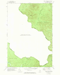
1970 Map of Merrill Mountain
USGS Topo · Published 1973About this map
The international boundary between Maine and Quebec defines this landscape in the northern reaches of Franklin County. Recorded in 1970, the topography is dominated by the steep slopes of Merrill Mountain, Van Dyke Mtn, and Caribou Mtn. These peaks overlook a network of logging camps and drainage systems that feed into the West Branch Moose River. Human presence is sparse, marked primarily by industrial outposts like Moose Mill Camp and the isolated Coburn Gore area in the south.
Find a feature on this map
23 named features on this map. Tap any name to fly to it.
Don’t see what you’re looking for? This feature index may not catch every label — zoom into the map to look around manually.
Map Details
Editions of this 1970 Merrill Mountain Map
This is the sole edition of this map. No revisions or reprints were ever made.
Other maps of this area

1928 · Chain Lakes
USGS Topo · 1:48,000

1928 · Skinner
USGS Topo · 1:48,000

1931 · Skinner
USGS Topo · 1:62,500

1932 · Arnold Pond
USGS Topo · 1:48,000

1932 · Chain Lakes
USGS Topo · 1:62,500

1935 · Chain Lakes
USGS Topo · 1:62,500

1935 · Arnold Pond
USGS Topo · 1:62,500

1949 · Jackman
USGS Topo · 1:250,000
1951 · Chain Lakes
USGS Topo · 1:50,000

1963 · Jackman
USGS Topo · 1:250,000