1980s Maps of Deer Isle, Maine
Explore 7 historic maps of Deer Isle from the 1980s. These maps offer a rare glimpse into what life looked like during the 1980s — showing old roads, neighborhoods, homes, and landmarks that have changed or disappeared over time.
Whether you're researching your family's past, planning a metal detecting trip, or studying how Deer Isle's landscape evolved across the 1980s, these high-resolution maps are a powerful tool for exploring the history of this region.
- Focus on a specific era: All maps on this page are from the 1980s, giving you a focused view of this time period.
- See what’s changed: Compare century-old streets, trails, and buildings to today's modern landscape using overlays and satellite layers.
- Research with precision: Use these maps for genealogy, historical research, land use analysis, or educational projects.
- View, download, or print: Maps are fully viewable online in high resolution, and can be downloaded or printed for your own records.
Start exploring Deer Isle's history through authentic maps from the 1980s. This is your window into the past.
Deer Isle, ME maps
(7)- 1981 Map of Brooklin
 1981 Brooklin1981 Print · USGSThe Hancock County coast at the start of the 1980s reveals a landscape of tidal marshes and tight-knit maritime villages. Researchers can trace ancestral roots through sites like Mt Ephraim Cem and the older Rural Cem, or locate family landmarks at Flye Point and Haven.
 - 1981 Map of Sargentville, 1982 Print
 1981 Sargentville1982 Print · USGSThe Maine coastline near the mouth of the Bagaduce River was a hub of seafaring and small-town life in the early eighties. Genealogists and historians can trace local family roots at Forest Home Cem, Ecce-mocin Ch, and the old Quarry on Little Deer Isle.2 unique versions available
 - 1982 Map of North Haven East, 1983 Print
 1982 North Haven East1983 Print · USGSThe Fox Islands archipelago in the early eighties highlights a seafaring community connected by the Fox Islands Thorofare and the North Haven Ferry. Genealogists can trace family lines through the Seaview Cem or explore the landing at The Wood Landing.
 - 1983 Map of Deer Isle
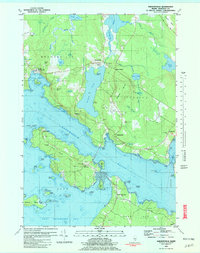
 1983 Deer Isle1983 Print · USGSDeer Isle and the busy harbor at Stonington appear in high detail during the early eighties. Researchers can trace family history at Mt Adams Cem or locate industrial sites like the quarries on Crotch Island and the Mark Island Lighthouse.
 - 1983 Map of Stinson Neck
 1983 Stinson Neck1983 Print · USGSCoastal Hancock County in the early eighties is captured here across the islands and reaches of Stinson Neck. Genealogists and historians can locate family-named points and settlements like Sunshine, Oceanville, and the Beth Eden Ch near Naskeag.
 - 1983 Map of North Haven West
 1983 North Haven West1983 Print · USGSMid-coast Maine’s maritime landscape is captured here in the early eighties, showing the intricate shorelines of Penobscot Bay. Genealogists and historians can trace coastal homesteads near Fuller Cem, landholdings on Seven Hundred Acre Island, and old routes like Main Road.
 - 1985 Map of Bar Harbor
 1985 Bar Harbor1985 Print · USGSCoastal Hancock County in the mid-eighties shows an intricate landscape of island communities and protected wilderness. Trace the boundaries of Acadia National Park or locate seafaring hubs like Stonington and Bar Harbor.2 unique versions available
End of results
Showing maps 1-7 of 7
Top cities near Deer Isle
- Blue Hill historical maps
- Searsport historical maps
- Surry historical maps
- Northport historical maps
- Tremont historical maps
- Stockton Springs historical maps
See more
Top neighborhoods of Deer Isle
- Sunset historical maps
- Eggemoggin historical maps
- Little Deer Isle historical maps
- Sunshine historical maps
- South Deer Isle historical maps
- North Deer Isle historical maps
See more
Frequently asked questions
- What are the different types of historical maps available for Deer Isle?
- What is the oldest map of Deer Isle?
- Where can I purchase historical maps of Deer Isle for my home or office?
- Where can I download high-res historical maps of Deer Isle?
- Are there historical topographic maps available for Deer Isle?
- Is there historical aerial imagery available for Deer Isle?
- Where are historical maps of Deer Isle sourced from?