1970s Maps of Deer Isle, Maine
Explore 2 historic maps of Deer Isle from the 1970s. These maps offer a rare glimpse into what life looked like during the 1970s — showing old roads, neighborhoods, homes, and landmarks that have changed or disappeared over time.
Whether you're researching your family's past, planning a metal detecting trip, or studying how Deer Isle's landscape evolved across the 1970s, these high-resolution maps are a powerful tool for exploring the history of this region.
- Focus on a specific era: All maps on this page are from the 1970s, giving you a focused view of this time period.
- See what’s changed: Compare century-old streets, trails, and buildings to today's modern landscape using overlays and satellite layers.
- Research with precision: Use these maps for genealogy, historical research, land use analysis, or educational projects.
- View, download, or print: Maps are fully viewable online in high resolution, and can be downloaded or printed for your own records.
Start exploring Deer Isle's history through authentic maps from the 1970s. This is your window into the past.
Deer Isle, ME maps
(2)- 1973 Map of Cape Rosier, 1976 Print
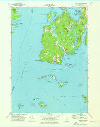 1973 Cape Rosier1976 Print · USGSCoastal Hancock County in the early seventies shows a landscape of granite heights and tidal reaches. Genealogists and historians can trace family-named sites like John B Mtn or find old burial grounds at Evergreen Cem and Bayview Cem.3 unique versions available
 - 1973 Map of Islesboro, 1976 Print
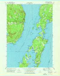 1973 Islesboro1976 Print · USGSThe islands of Penobscot Bay appear in the 1970s, showcasing the maritime connections of Islesboro and Dark Harbor. Trace local genealogy and landmarks across Seven Hundred Acre Island, the Saturday Cove Cem, and the Islesboro Ferry Toll.2 unique versions available
End of results
Showing maps 1-2 of 2
Top cities near Deer Isle
- Blue Hill historical maps
- Searsport historical maps
- Surry historical maps
- Northport historical maps
- Tremont historical maps
- Stockton Springs historical maps
See more
Top neighborhoods of Deer Isle
- Sunset historical maps
- Eggemoggin historical maps
- Little Deer Isle historical maps
- Sunshine historical maps
- South Deer Isle historical maps
- North Deer Isle historical maps
See more
Frequently asked questions
- What are the different types of historical maps available for Deer Isle?
- What is the oldest map of Deer Isle?
- Where can I purchase historical maps of Deer Isle for my home or office?
- Where can I download high-res historical maps of Deer Isle?
- Are there historical topographic maps available for Deer Isle?
- Is there historical aerial imagery available for Deer Isle?
- Where are historical maps of Deer Isle sourced from?