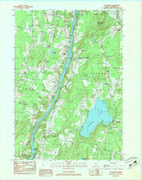
1900s (20th Century) Maps of Sidney, Maine
Explore 23 historic maps of Sidney from the 1900s (20th Century). These maps offer a rare glimpse into what life looked like during the 1900s — showing old roads, neighborhoods, homes, and landmarks that have changed or disappeared over time.
Whether you're researching your family's past, planning a metal detecting trip, or studying how Sidney's landscape evolved across the 1900s, these high-resolution maps are a powerful tool for exploring the history of this region.
- Focus on a specific era: All maps on this page are from the 1900s, giving you a focused view of this time period.
- See what’s changed: Compare century-old streets, trails, and buildings to today's modern landscape using overlays and satellite layers.
- Research with precision: Use these maps for genealogy, historical research, land use analysis, or educational projects.
- View, download, or print: Maps are fully viewable online in high resolution, and can be downloaded or printed for your own records.
Start exploring Sidney's history through authentic maps from the 1900s. This is your window into the past.
Sidney, ME maps
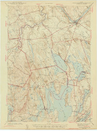
(23)- 1941 Map of Vassalboro, 1954 Print
 1941 Vassalboro1954 Print · USGSCentral Maine in the early 1940s reveals a landscape of lakeside settlements and scattered rural schoolhouses between the Kennebec and Sheepscot rivers. Genealogists can trace family roots through sites like Oak Grove Seminary, Friends Cem, and Weeks Mills.2 unique versions available
 - 1941 Map of Augusta, 1956 Print
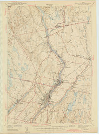
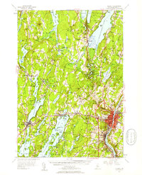
 1941 Augusta1956 Print · USGSThe Kennebec River valley and its surrounding lake country are documented here just before the mid-century, showing the capital's growth alongside quiet rural townships. Genealogists can locate family-named sites like Stevens Cem, several small schoolhouses including Cony Sch, and the rail stops at Readfield Depot.
 - 1943 Map of Augusta
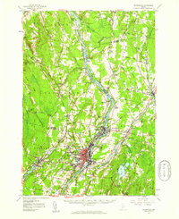
 1943 Augusta1943 Print · USGSAugusta and the surrounding Kennebec County lakes are shown in detail during the early 1940s as the rail and river economies converged. Genealogists can locate family plots at Lakeview Cem, trace old school districts like Ballard Sch, and find landmarks like the Fish Hatchery.3 unique versions available
 - 1943 Map of Vassalboro
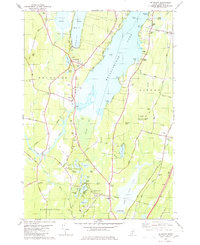
 1943 Vassalboro1943 Print · USGSCentral Maine in the early 1940s is a landscape of expansive lake systems and interconnected mill villages. Researchers can trace the heritage of local institutions like Oak Grove Seminary, the stop at Windsor Station, and the historic Friends Cem.
 - 1943 Map of Norridgewock
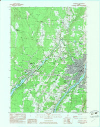
 1943 Norridgewock1943 Print · USGSSomerset and Kennebec counties are shown here just after the start of the war, when the Maine Central railroad still connected these rural river towns. Researchers can locate specific family landmarks including the Whitehouse Cem, Hersom Sch, and the Norridgewock Rearing Pool.3 unique versions available
 - 1943 Map of Waterville
 1943 Waterville1943 Print · USGSThe Kennebec and Sebasticook river valleys are shown in detail during the early 1940s, highlighting the rail hubs of Waterville and Winslow. Genealogists can trace family landmarks like Pratt Cem or the rural Covell Sch and Ten Lots Chapel.2 unique versions available
 - 1948 Map of Bangor
 1948 Bangor1948 Print · USGSThe Maine coast and its industrial river valleys are captured here shortly after the war, showing the vital shipping and rail hubs of the late 1940s. Genealogists and historians can trace the tracks of the Maine Central RR connecting Bangor, Augusta, and Old Town.
 - 1956 Map of Norridgewock, 1958 Print
 1956 Norridgewock1958 Print · USGSSomerset and Kennebec counties are shown here in the mid-1950s, centered on the river convergence at Norridgewock. Genealogists and historians can trace local school districts like Whittier Sch and explore lakefront landmarks including Camp Abena and The Serpentine.3 unique versions available
 - 1956 Map of Vassalboro, 1958 Print
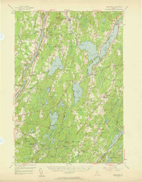 1956 Vassalboro1958 Print · USGSThe Kennebec River valley and the shores of China Lake are captured here during the mid-fifties. Researchers can trace historic institutions and rural centers like the Oak Grove Seminary, Erskine Academy, and the Windsor Fairgrounds.3 unique versions available
 - 1956 Map of Augusta, 1958 Print
 1956 Augusta1958 Print · USGSMaine’s capital city and the surrounding lake country appear here in the mid-fifties as the region’s recreation and rail economies thrived. Genealogists and local historians can locate many small family cemeteries like Tiffany Cem and Stevens Cem, or trace the old rail stops at Readfield Sta.4 unique versions available
 - 1956 Map of Bangor, 1966 Print
 1956 Bangor1966 Print · USGSMid-century Maine comes alive in this survey of the rugged coast and river valleys during the 1950s. Genealogists and historians can trace the vital rail corridors of the Maine Central RR connecting timber towns like Old Town to the coast at Bar Harbor.3 unique versions available
 - 1957 Map of Waterville, 1959 Print
 1957 Waterville1959 Print · USGSThe Kennebec River valley in the late fifties shows a bustling industrial landscape centered on the rail-and-river hub of Waterville. Researchers can trace historic institutions like Colby College, the Central Maine Sanatorium, and family-named sites such as Pishon Ferry or Ten Lots Chapel.3 unique versions available
 - 1960 Map of Bangor
 1960 Bangor1960 Print · USGSCentral Maine in the sixties reveals a landscape of river-powered industry and sprawling coastal island chains. Researchers can trace the rail corridors of the Maine Central or locate mid-century aviation landmarks like Dow Air Force Base.
 - 1961 Map of Bangor
 1961 Bangor1961 Print · USGSMid-century Maine comes alive through its busy river ports and rocky archipelagoes during a period of steady maritime and rail commerce. Researchers can trace the path of the Maine Central railroad and locate coastal landmarks from Acadia National Park to Vinalhaven Island.
 - 1975 Map of Norridgewock SE, 1980 Print
 1975 Norridgewock SE1980 Print · USGSThe Belgrade Lakes region comes into sharp focus in the mid-1970s through this detailed orthophoto. Researchers can trace the exact development of shoreline settlements and rural crossroads like North Belgrade, Tyler Corner, and Rome.
 - 1975 Map of Vassalboro NW, 1980 Print
 1975 Vassalboro NW1980 Print · USGSThe Kennebec River valley in the mid-seventies is documented here through high-resolution aerial photography. Genealogists and local historians can pinpoint exact homesteads and field boundaries near North Vassalboro, Riverside, and Webber Pond.
 - 1975 Map of Waterville SW, 1980 Print
 1975 Waterville SW1980 Print · USGSThe mid-1970s landscape of Kennebec County is captured in this aerial survey, showcasing the urban layout and industrial riverfronts of central Maine. Local historians can trace the growth of Waterville and Oakland alongside the Kennebec River.
 - 1980 Map of Belgrade
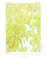
 1980 Belgrade1980 Print · USGSThe Belgrade Lakes region in the late twentieth century reveals a landscape of summer camps, rail-side hamlets, and old farmsteads. Genealogists can trace family names at Pine Grove Cem, Steadman Cem, and the Tiffany Hill Chapel.2 unique versions available
 - 1982 Map of Rome
 1982 Rome1982 Print · USGSThe Belgrade Lakes region comes into focus during the early eighties, showcasing a complex network of waterways and lakeside settlements. Trace historical land markers and rail lines like the Stone Town Bdry Mon and the Maine Central near North Belgrade.
 - 1982 Map of Waterville, 1983 Print
 1982 Waterville1983 Print · USGSWaterville and Winslow thrived as industrial and academic centers during the early eighties, centered on the powerful Kennebec River. Genealogists and historians can trace the campuses of Colby College and Thomas College or locate family plots in Lakeview Cem and Drummond Cem.3 unique versions available
 - 1983 Map of Vassalboro
 1983 Vassalboro1983 Print · USGSKennebec County comes into focus in the early 1980s as the river and rail network define life between Sidney and Vassalboro. Genealogists and historians can trace family roots through numerous burial grounds like Bowman Cem and landmarks such as Seaward Mills or the Oak Grove-Coburn Sch.2 unique versions available
 - 1984 Map of Augusta
 1984 Augusta1984 Print · USGSMid-coast and central Maine were undergoing steady change in the mid-eighties as traditional river and coastal industries met expanding recreation. You can trace the Maine Central RR through Augusta or explore the rugged shoreline from Rockland Harbor up to Mount Megunticook.
 - 1985 Map of Skowhegan, 1986 Print
 1985 Skowhegan1986 Print · USGSCentral Maine in the mid-eighties shows a landscape of river-driven industry and rural crossroads. Genealogists can trace family names and farmsteads near Lake George or along the Maine Central Railroad through Pittsfield and Burnham.2 unique versions available
End of results
Showing maps 1-23 of 23
Top cities near Sidney
- Augusta historical maps
- Waterville historical maps
- Winslow historical maps
- Fairfield historical maps
- Oakland historical maps
- Winthrop historical maps
See more
Top neighborhoods of Sidney
Frequently asked questions
- What are the different types of historical maps available for Sidney?
- What is the oldest map of Sidney?
- Where can I purchase historical maps of Sidney for my home or office?
- Where can I download high-res historical maps of Sidney?
- Are there historical topographic maps available for Sidney?
- Is there historical aerial imagery available for Sidney?
- Where are historical maps of Sidney sourced from?