1950s Maps of Sidney, Maine
Explore 5 historic maps of Sidney from the 1950s. These maps offer a rare glimpse into what life looked like during the 1950s — showing old roads, neighborhoods, homes, and landmarks that have changed or disappeared over time.
Whether you're researching your family's past, planning a metal detecting trip, or studying how Sidney's landscape evolved across the 1950s, these high-resolution maps are a powerful tool for exploring the history of this region.
- Focus on a specific era: All maps on this page are from the 1950s, giving you a focused view of this time period.
- See what’s changed: Compare century-old streets, trails, and buildings to today's modern landscape using overlays and satellite layers.
- Research with precision: Use these maps for genealogy, historical research, land use analysis, or educational projects.
- View, download, or print: Maps are fully viewable online in high resolution, and can be downloaded or printed for your own records.
Start exploring Sidney's history through authentic maps from the 1950s. This is your window into the past.
Sidney, ME maps
(5)- 1956 Map of Norridgewock, 1958 Print
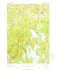 1956 Norridgewock1958 Print · USGSSomerset and Kennebec counties are shown here in the mid-1950s, centered on the river convergence at Norridgewock. Genealogists and historians can trace local school districts like Whittier Sch and explore lakefront landmarks including Camp Abena and The Serpentine.3 unique versions available
 - 1956 Map of Vassalboro, 1958 Print
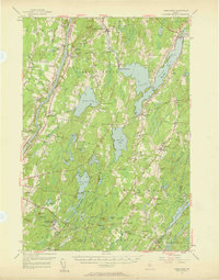 1956 Vassalboro1958 Print · USGSThe Kennebec River valley and the shores of China Lake are captured here during the mid-fifties. Researchers can trace historic institutions and rural centers like the Oak Grove Seminary, Erskine Academy, and the Windsor Fairgrounds.3 unique versions available
 - 1956 Map of Augusta, 1958 Print
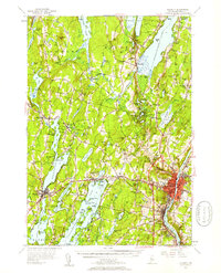 1956 Augusta1958 Print · USGSMaine’s capital city and the surrounding lake country appear here in the mid-fifties as the region’s recreation and rail economies thrived. Genealogists and local historians can locate many small family cemeteries like Tiffany Cem and Stevens Cem, or trace the old rail stops at Readfield Sta.4 unique versions available
 - 1956 Map of Bangor, 1966 Print
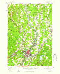
 1956 Bangor1966 Print · USGSMid-century Maine comes alive in this survey of the rugged coast and river valleys during the 1950s. Genealogists and historians can trace the vital rail corridors of the Maine Central RR connecting timber towns like Old Town to the coast at Bar Harbor.3 unique versions available
 - 1957 Map of Waterville, 1959 Print
 1957 Waterville1959 Print · USGSThe Kennebec River valley in the late fifties shows a bustling industrial landscape centered on the rail-and-river hub of Waterville. Researchers can trace historic institutions like Colby College, the Central Maine Sanatorium, and family-named sites such as Pishon Ferry or Ten Lots Chapel.3 unique versions available
End of results
Showing maps 1-5 of 5
Top cities near Sidney
- Augusta historical maps
- Waterville historical maps
- Winslow historical maps
- Fairfield historical maps
- Oakland historical maps
- Winthrop historical maps
See more
Top neighborhoods of Sidney
Frequently asked questions
- What are the different types of historical maps available for Sidney?
- What is the oldest map of Sidney?
- Where can I purchase historical maps of Sidney for my home or office?
- Where can I download high-res historical maps of Sidney?
- Are there historical topographic maps available for Sidney?
- Is there historical aerial imagery available for Sidney?
- Where are historical maps of Sidney sourced from?