1960s Maps of Lincoln County, Maine
Explore 11 historic maps of Lincoln County from the 1960s. These maps offer a rare glimpse into what life looked like during the 1960s — showing old roads, neighborhoods, homes, and landmarks that have changed or disappeared over time.
Whether you're researching your family's past, planning a metal detecting trip, or studying how Lincoln County's landscape evolved across the 1960s, these high-resolution maps are a powerful tool for exploring the history of this region.
- Focus on a specific era: All maps on this page are from the 1960s, giving you a focused view of this time period.
- See what’s changed: Compare century-old streets, trails, and buildings to today's modern landscape using overlays and satellite layers.
- Research with precision: Use these maps for genealogy, historical research, land use analysis, or educational projects.
- View, download, or print: Maps are fully viewable online in high resolution, and can be downloaded or printed for your own records.
Start exploring Lincoln County's history through authentic maps from the 1960s. This is your window into the past.
Lincoln County, ME maps
(11)- 1960 Map of Bangor
 1960 Bangor1960 Print · USGSCentral Maine in the sixties reveals a landscape of river-powered industry and sprawling coastal island chains. Researchers can trace the rail corridors of the Maine Central or locate mid-century aviation landmarks like Dow Air Force Base.
 - 1961 Map of Bangor
 1961 Bangor1961 Print · USGSMid-century Maine comes alive through its busy river ports and rocky archipelagoes during a period of steady maritime and rail commerce. Researchers can trace the path of the Maine Central railroad and locate coastal landmarks from Acadia National Park to Vinalhaven Island.
 - 1961 Map of Razorville, 1964 Print
 1961 Razorville1964 Print · USGSCoastal Maine's interior comes into focus during the early sixties, showing a landscape of unincorporated gores and rural plantations. Genealogists can trace family names at Hannan Cem and Lenfest Cem or locate the Sandhill Sch near Sandhill Corner.3 unique versions available
 - 1963 Map of Bath
 1963 Bath1963 Print · USGSThe Maine Midcoast in the early sixties remains a world of tidal rivers and jagged peninsulas tied to the sea. Genealogy and local history researchers can trace the rail lines of the Maine Central RR and locate offshore communities like Matinicus Island and Monhegan.2 unique versions available
 - 1965 Map of Bath
 1965 Bath1965 Print · USGSThe Midcoast Maine shoreline and its archipelago come alive in the mid-1960s, showing the region's deep reliance on river and rail. Researchers can trace historic harbor towns like Boothbay Harbor and Damariscotta, and locate coastal landmarks from Pemaquid Point to the Fort Popham Military Res.
 - 1965 Map of Jefferson, 1967 Print
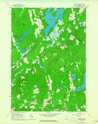
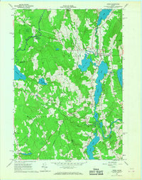
 1965 Jefferson1967 Print · USGSMid-coast Maine’s wooded hills and lakefronts are captured here in the mid-1960s, showing a landscape of small crossroads and river rapids. Researchers can trace family-named locales like Kennedy Corner, Orffs Corner, and the rural community of North Waldoboro along the Medomak River.4 unique versions available
 - 1965 Map of Waldoboro West, 1967 Print
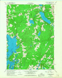
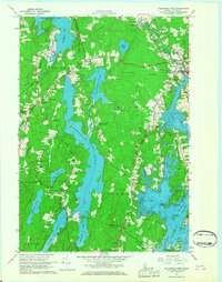 1965 Waldoboro West1967 Print · USGSCoastal Lincoln County in the mid-sixties shows a landscape of tidal rivers and scattered forest hamlets. Genealogists can locate family landmarks from Harrington Corner to Winslows Mills, alongside local institutions like St Pauls Chapel and the Miller School.5 unique versions available
 - 1965 Map of Union, 1967 Print
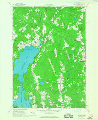
 1965 Union1967 Print · USGSKnox County is captured in the mid-sixties as a landscape of interconnected ponds and rural hamlets. Local historians can trace the Old Railroad Grade and identify family-named crossroads like Whitney Corner and Manks Corner.4 unique versions available
 - 1965 Map of Waldoboro East, 1968 Print
 1965 Waldoboro East1968 Print · USGSCoastal Maine in the mid-1960s reveals a landscape defined by tidal rivers and the Maine Central rail line. Genealogists and local historians can trace small settlements and family landmarks from South Waldoboro to the Cushing Sch and Warren Station.3 unique versions available
 - 1969 Map of Pemaquid Point, 1973 Print
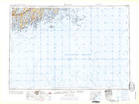
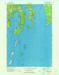 1969 Pemaquid Point1973 Print · USGSThe Lincoln County coast comes alive in this late-1960s survey of its rocky peninsulas and sheltered harbors. You can trace the historic shoreline from the Pemaquid Lighthouse to the docks at New Harbor and the quiet reaches of Christmas Cove.3 unique versions available
 - 1969 Map of Bristol, 1974 Print
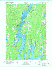 1969 Bristol1974 Print · USGSCoastal Lincoln County is mapped here in the late sixties, revealing the intricate shorelines of the Damariscotta River and its many tidal coves. Genealogists and historians can locate the Old Walpole Meetinghouse, trace family plots at the West Bristol Cem, and explore the shoreline of Pemaquid Harbor.
End of results
Showing maps 1-11 of 11
Top cities of Lincoln County
- Wiscasset historical maps
- Boothbay historical maps
- Bristol historical maps
- Jefferson historical maps
- Whitefield historical maps
- Damariscotta historical maps
See more
Frequently asked questions
- What are the different types of historical maps available for Lincoln County?
- What is the oldest map of Lincoln County?
- Where can I purchase historical maps of Lincoln County for my home or office?
- Where can I download high-res historical maps of Lincoln County?
- Are there historical topographic maps available for Lincoln County?
- Is there historical aerial imagery available for Lincoln County?
- Where are historical maps of Lincoln County sourced from?