1990s Maps of Oxford, Maine
Explore 1 historic maps of Oxford from the 1990s. These maps offer a rare glimpse into what life looked like during the 1990s — showing old roads, neighborhoods, homes, and landmarks that have changed or disappeared over time.
Whether you're researching your family's past, planning a metal detecting trip, or studying how Oxford's landscape evolved across the 1990s, these high-resolution maps are a powerful tool for exploring the history of this region.
- Focus on a specific era: All maps on this page are from the 1990s, giving you a focused view of this time period.
- See what’s changed: Compare century-old streets, trails, and buildings to today's modern landscape using overlays and satellite layers.
- Research with precision: Use these maps for genealogy, historical research, land use analysis, or educational projects.
- View, download, or print: Maps are fully viewable online in high resolution, and can be downloaded or printed for your own records.
Start exploring Oxford's history through authentic maps from the 1990s. This is your window into the past.
Oxford, ME maps
(1)- 1995 Map of Mechanic Falls, 1999 Print
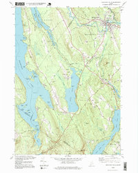 1995 Mechanic Falls1999 Print · USGSSouthern Maine in the mid-nineties shows a landscape of river-driven industry and growing lakefront communities at the meeting of three counties. Researchers can locate family sites near West Poland, trace the Grand Trunk RR, or find Highland Cem and Elm Street Sch.
End of results
Showing maps 1-1 of 1
Top cities near Oxford
- Auburn historical maps
- Gray historical maps
- Turner historical maps
- Poland historical maps
- New Gloucester historical maps
- Bridgton historical maps
See more
Top neighborhoods of Oxford
- Pratt Corner historical maps
- Oxford Station historical maps
- Paine Corner historical maps
- Caldwell Corner historical maps
- Welchville historical maps
Frequently asked questions
- What are the different types of historical maps available for Oxford?
- What is the oldest map of Oxford?
- Where can I purchase historical maps of Oxford for my home or office?
- Where can I download high-res historical maps of Oxford?
- Are there historical topographic maps available for Oxford?
- Is there historical aerial imagery available for Oxford?
- Where are historical maps of Oxford sourced from?