Old Maps of East Sweden, Sweden for Genealogy
Trace your family roots with 16 historic maps of East Sweden. These high-res maps reveal old neighborhoods, homesites, landmarks, and streets — helping you uncover where your ancestors lived and how the area evolved over time.
- Explore historic neighborhoods: Identify where your relatives may have lived in the 1800s or 1900s.
- Compare maps over time: Trace the changes in streets, buildings, and landmarks for multi-generational research.
- Perfect for genealogy & ancestry research: Used by family historians and researchers to map out lineage and migration.
These maps are an incredible resource for exploring your personal connection to East Sweden's past.
East Sweden, Sweden maps
(16)- 1909 Map of Fryeburg, 1960 Print
 1909 Fryeburg1960 Print · USGSOxford County and the borderlands of Maine and New Hampshire were defined by the shifting waters of the Saco and the Kezar at the century's turn. Genealogists can trace family homesteads near the Battle Monument or locate rural schoolhouses like Foxboro School and Menotomy School.3 unique versions available
 - 1911 Map of Fryeburg
 1911 Fryeburg1911 Print · USGSOxford County at the start of the century shows a landscape of lake-fed valleys and the bustling rail corridor of the Maine Central RR. Genealogists and historians can trace old school districts like Foxboro School, local landmarks like the Battle Monument, and early settlements at Slab City and Lynchville.6 unique versions available
 - 1941 Map of Fryeburg
 1941 Fryeburg1941 Print · USGSOxford County and the Maine-New Hampshire borderlands are captured here just before the war, showcasing a landscape of isolated hills and interconnected lakes. Genealogists can locate family-named landmarks like Mc Daniels Hill and numerous rural schools including Plummer Sch and Black Mountain Sch.
 - 1950 Map of Lewiston
 1950 Lewiston1950 Print · USGSThe Maine and New Hampshire borderlands come alive in this post-war survey of the White Mountains and Androscoggin valley. Genealogists and historians can trace rail lines like the Maine Central Railroad and find high-altitude landmarks from Mount Washington to Bretton Woods.2 unique versions available
 - 1956 Map of Lewiston, 1975 Print
 1956 Lewiston1975 Print · USGSThe Northern New England interior is documented here in the mid-fifties, from the industrial Androscoggin River to the high peaks of the White Mountains. Trace the Grand Trunk Railway through mountain passes or locate family landmarks near Sabbathday Lake and Bretton Woods.
 - 1961 Map of Lewiston
 1961 Lewiston1961 Print · USGSWestern Maine and the White Mountains appear here during the early sixties, showing the industrial river towns and vast timberlands before the modern interstate era. Genealogists and historians can trace the Grand Trunk RR through Berlin or locate landmarks like Old Speck Mountain and Elephant Mountain.
 - 1962 Map of Lewiston
 1962 Lewiston1962 Print · USGSThe industrial river valleys and high peaks of Maine and New Hampshire define the region in the early sixties. Trace the rail-and-river network from Lewiston to the White Mountains, passing through mill towns like Berlin and Rumford.
 - 1963 Map of North Waterford, 1964 Print
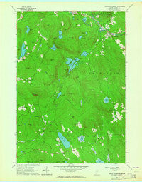 1963 North Waterford1964 Print · USGSOxford County in the early sixties is a landscape of high timber and interconnected glacial lakes before the era of major development. Researchers can trace historic family burial sites like Brackett Cem and explore old settlements from Slab City to Lynchville.2 unique versions available
 - 1969 Map of Lewiston
 1969 Lewiston1969 Print · USGSThe northern New England highlands come into focus during the mid-fifties, showing the vital rail and river networks connecting industrial centers to the deep woods. Researchers can trace the path of the Grand Trunk RR or locate landmarks like Mt Washington and Rangeley Lake.
 - 1986 Map of Lewiston
 1986 Lewiston1986 Print · USGSMaine’s industrial river valleys and western mountain foothills are captured here in the mid-eighties as rail and road networks tied the region together. Genealogists and historians can trace the development of mill towns and lakefront settlements from Lisbon to Bethel, following the Androscoggin River and the path of the Maine Central Railroad.2 unique versions available
 - 1995 Map of North Waterford, 2000 Print
 1995 North Waterford2000 Print · USGSOxford County in the late twentieth century remains a landscape of high ridges and glacial ponds, where timber and local industry shaped the rural layout. Genealogists can locate several family burial sites like Webber Cemetery and Haskell Cemetery or trace the early paths through Slab City and Lynchville.
 - 2012 Map of North Waterford, 2012 Print
 2012 North Waterford2012 Print · USGSCovers East Sweden, including Waterford, Lovell, and other nearby areas
 - 2014 Map of North Waterford, 2014 Print
 2014 North Waterford2014 Print · USGSCovers East Sweden, including Waterford, Lovell, and other nearby areas
 - 2018 Map of North Waterford, 2018 Print
 2018 North Waterford2018 Print · USGSCovers East Sweden, including Waterford, Lovell, and other nearby areas
 - 2021 Map of North Waterford, 2021 Print
 2021 North Waterford2021 Print · USGSCovers East Sweden, including Waterford, Lovell, and other nearby areas
 - 2024 Map of North Waterford, 2024 Print
 2024 North Waterford2024 Print · USGSThe hill country of western Maine is captured here in the twenty-first century, showing the enduring rural character of Oxford County. Researchers can trace family plots at Haskell Cem or Woodlawn Cem and explore the rugged landscape around Kezar Falls Gorge.
End of results
Showing maps 1-16 of 16
Frequently asked questions
- What are the different types of historical maps available for East Sweden?
- What is the oldest map of East Sweden?
- Where can I purchase historical maps of East Sweden for my home or office?
- Where can I download high-res historical maps of East Sweden?
- Are there historical topographic maps available for East Sweden?
- Is there historical aerial imagery available for East Sweden?
- Where are historical maps of East Sweden sourced from?