1940s Maps of Waterford, Maine
Explore 6 historic maps of Waterford from the 1940s. These maps offer a rare glimpse into what life looked like during the 1940s — showing old roads, neighborhoods, homes, and landmarks that have changed or disappeared over time.
Whether you're researching your family's past, planning a metal detecting trip, or studying how Waterford's landscape evolved across the 1940s, these high-resolution maps are a powerful tool for exploring the history of this region.
- Focus on a specific era: All maps on this page are from the 1940s, giving you a focused view of this time period.
- See what’s changed: Compare century-old streets, trails, and buildings to today's modern landscape using overlays and satellite layers.
- Research with precision: Use these maps for genealogy, historical research, land use analysis, or educational projects.
- View, download, or print: Maps are fully viewable online in high resolution, and can be downloaded or printed for your own records.
Start exploring Waterford's history through authentic maps from the 1940s. This is your window into the past.
Waterford, ME maps
(6)- 1940 Map of Bethel, 1958 Print
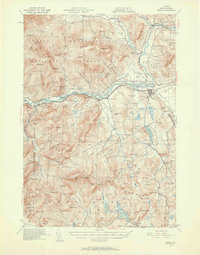 1940 Bethel1958 Print · USGSOxford County at the dawn of the 1940s reveals a landscape of river-valley farming and mountain timberlands. Genealogists and local historians can locate early district schools like Sunday River Sch, the Town House in Albany, and mountain notches like Tyler Notch.2 unique versions available
 - 1941 Map of Bethel
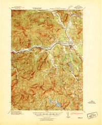 1941 Bethel1941 Print · USGSOxford County was a landscape of mountain ridges and narrow river valleys just before the mid-century, centered on the Androscoggin River. Genealogists can trace family names and rural landmarks like the Bethel Cem, Mason School, and the village at Town House.
 - 1941 Map of Fryeburg
 1941 Fryeburg1941 Print · USGSOxford County and the Maine-New Hampshire borderlands are captured here just before the war, showcasing a landscape of isolated hills and interconnected lakes. Genealogists can locate family-named landmarks like Mc Daniels Hill and numerous rural schools including Plummer Sch and Black Mountain Sch.
 - 1942 Map of Bryant Pond
 1942 Bryant Pond1942 Print · USGSOxford County at the dawn of the 1940s shows a landscape of mountain ridges and busy valley railroads. Genealogists can locate family-named landmarks like Walkers Mill and Trap Corner or trace rural education at the Millettville Sch and Patch Mountain Sch.
 - 1946 Map of Norway, 1955 Print
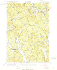 1946 Norway1955 Print · USGSMid-century Oxford County is defined by its deep lake system and timber-driven river settlements before the arrival of modern interstates. Genealogists and historians can trace family plots at Bisbeetown Cem, locate the old Lewis Sch, and find historical hubs like Scribners Mill and the Fairgrounds.4 unique versions available
 - 1949 Map of Norway
 1949 Norway1949 Print · USGSOxford County and the upper Cumberland lakes region are shown here in the mid-forties, capturing the era of small-town mills and rail-fed industry. Genealogists and historians can trace family locations through Bisbeetown Cem, Scribners Mill, and the historic Bell Hill Meeting House.2 unique versions available
End of results
Showing maps 1-6 of 6
Top cities near Waterford
- Bridgton historical maps
- Paris historical maps
- Norway historical maps
- Raymond historical maps
- Oxford historical maps
- Naples historical maps
See more
Top neighborhoods of Waterford
- North Waterford historical maps
- Sodom historical maps
- South Waterford historical maps
- Waterford Flat historical maps
- East Waterford historical maps
Frequently asked questions
- What are the different types of historical maps available for Waterford?
- What is the oldest map of Waterford?
- Where can I purchase historical maps of Waterford for my home or office?
- Where can I download high-res historical maps of Waterford?
- Are there historical topographic maps available for Waterford?
- Is there historical aerial imagery available for Waterford?
- Where are historical maps of Waterford sourced from?