1980s Maps of Etna, Maine
Explore 5 historic maps of Etna from the 1980s. These maps offer a rare glimpse into what life looked like during the 1980s — showing old roads, neighborhoods, homes, and landmarks that have changed or disappeared over time.
Whether you're researching your family's past, planning a metal detecting trip, or studying how Etna's landscape evolved across the 1980s, these high-resolution maps are a powerful tool for exploring the history of this region.
- Focus on a specific era: All maps on this page are from the 1980s, giving you a focused view of this time period.
- See what’s changed: Compare century-old streets, trails, and buildings to today's modern landscape using overlays and satellite layers.
- Research with precision: Use these maps for genealogy, historical research, land use analysis, or educational projects.
- View, download, or print: Maps are fully viewable online in high resolution, and can be downloaded or printed for your own records.
Start exploring Etna's history through authentic maps from the 1980s. This is your window into the past.
Etna, ME maps
(5)- 1982 Map of Dixmont
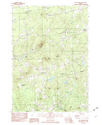
 1982 Dixmont1982 Print · USGSPenobscot and Waldo counties appear here in the early eighties as a landscape of crossroads hamlets and family farmsteads. Genealogists can trace rural roots through scattered sites like Sawyer Cem and Mt Holly Cem, or locate the Mount Harris Lookout Tower.2 unique versions available
 - 1982 Map of Plymouth, 1983 Print
 1982 Plymouth1983 Print · USGSPenobscot County landscape in the early eighties shows a transition from lakeside settlements to high-elevation timber and training grounds. Genealogists can locate family landmarks like Palmer Cem or the Emmanuel Ch near the banks of Plymouth Pond.
 - 1982 Map of Carmel, 1983 Print
 1982 Carmel1983 Print · USGSPenobscot County's rural townships are shown here in the early eighties as the local landscape balanced small-town life with seasonal recreation. Genealogists and local historians can locate family plots at Highland Cem, trace the settlement at Damascus, or find old landmarks like Ring Hill Airport.2 unique versions available
 - 1982 Map of East Dixmont, 1983 Print
 1982 East Dixmont1983 Print · USGSPenobscot and Waldo counties meet in this early 1980s look at rural Maine as it transitioned between traditional farming and modern infrastructure. Genealogists can locate over a dozen family burial grounds including Bean Cem and Lufkin Cem, while tracing old routes like North Road.2 unique versions available
 - 1985 Map of Skowhegan, 1986 Print
 1985 Skowhegan1986 Print · USGSCentral Maine in the mid-eighties shows a landscape of river-driven industry and rural crossroads. Genealogists can trace family names and farmsteads near Lake George or along the Maine Central Railroad through Pittsfield and Burnham.2 unique versions available
End of results
Showing maps 1-5 of 5
Top cities near Etna
- Hampden historical maps
- Hermon historical maps
- Glenburn historical maps
- Pittsfield historical maps
- Winterport historical maps
- Dexter historical maps
See more
Top neighborhoods of Etna
Frequently asked questions
- What are the different types of historical maps available for Etna?
- What is the oldest map of Etna?
- Where can I purchase historical maps of Etna for my home or office?
- Where can I download high-res historical maps of Etna?
- Are there historical topographic maps available for Etna?
- Is there historical aerial imagery available for Etna?
- Where are historical maps of Etna sourced from?