1900s (20th Century) Maps of Howland, Maine
Explore 22 historic maps of Howland from the 1900s (20th Century). These maps offer a rare glimpse into what life looked like during the 1900s — showing old roads, neighborhoods, homes, and landmarks that have changed or disappeared over time.
Whether you're researching your family's past, planning a metal detecting trip, or studying how Howland's landscape evolved across the 1900s, these high-resolution maps are a powerful tool for exploring the history of this region.
- Focus on a specific era: All maps on this page are from the 1900s, giving you a focused view of this time period.
- See what’s changed: Compare century-old streets, trails, and buildings to today's modern landscape using overlays and satellite layers.
- Research with precision: Use these maps for genealogy, historical research, land use analysis, or educational projects.
- View, download, or print: Maps are fully viewable online in high resolution, and can be downloaded or printed for your own records.
Start exploring Howland's history through authentic maps from the 1900s. This is your window into the past.
Howland, ME maps
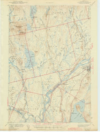
(22)- 1917 Map of Passadumkeag
 1917 Passadumkeag1917 Print · USGSIn the early twentieth century, the Penobscot River valley was a busy corridor of rail transit and small-town commerce. Genealogists can trace family footprints through numerous local schools like Hemlock School and the post office at West Enfield P.O.7 unique versions available
 - 1933 Map of Boyd Lake
 1933 Boyd Lake1933 Print · USGSPenobscot County communities and the Piscataquis River valley are captured here in the early thirties as the railroad remained the lifeblood of rural Maine. Local historians can trace numerous family-named landmarks and district schoolhouses like Knowles Sch, Ridge Sch, and the Huntington Mill works.
 - 1942 Map of Lincoln
 1942 Lincoln1942 Print · USGSPenobscot River life and the timber-driven rail economy are captured here during the early years of the war. Genealogists and historians can locate old landmarks like Merrifield Sch, the Ridge Cem, and the river island communities of the Penobscot Indian Reservation.3 unique versions available
 - 1947 Map of Schoodic, 1956 Print
 1947 Schoodic1956 Print · USGSPiscataquis County in the late 1940s is shown here as a landscape of timber, rail, and isolated lake settlements. Genealogists and historians can trace old homesteads and landmarks like Evergreen Cem, the Maxfield Sch, and the rail stops at Packards or Lake View.3 unique versions available
 - 1949 Map of Schoodic
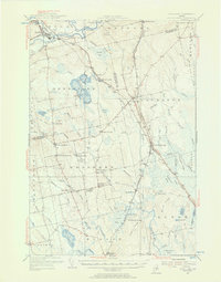
 1949 Schoodic1949 Print · USGSThe rail-and-river network of central Maine is captured here just after the war, showing the junction of two major rail lines. Genealogists and historians can trace old community sites like Lake View, Knights Landing, and the Maxfield Sch.2 unique versions available
 - 1951 Map of Boyd Lake
 1951 Boyd Lake1951 Print · USGSPenobscot and Piscataquis Counties are captured here in the early 1950s, showing a landscape of timber-rail economies and scattered rural schoolhouses. Genealogists can trace family footprints at Bradford Center, the Hoxie Sch, or along the Bangor and Aroostook rail line.
 - 1954 Map of Millinocket, 1968 Print
 1954 Millinocket1968 Print · USGSMaine's North Woods and the Penobscot Valley are captured here during the mid-century era of logging and rail dominance. You can trace the path of the Bangor and Aroostook Railroad through timber towns like Millinocket, Mattawamkeag, and Silver Ridge.3 unique versions available
 - 1955 Map of Boyd Lake, 1956 Print
 1955 Boyd Lake1956 Print · USGSPenobscot and Piscataquis counties are captured here in the mid-fifties as the rail-and-river economy supported towns like Milo and Derby. Genealogists can locate family landmarks such as the Orneville Sch, Williams Cem, and the Bradford High Sch.4 unique versions available
 - 1957 Map of Lincoln, 1959 Print
 1957 Lincoln1959 Print · USGSPenobscot River towns and the Maine woods are captured here in the late fifties, showing the vital rail-and-river corridor. Genealogists and historians can trace rail lines like the Maine Central, locate the Fairfield Sch, and find the remote Mattamiscontis Club Camp.3 unique versions available
 - 1958 Map of Millinocket
 1958 Millinocket1958 Print · USGSMaine's North Woods and the Penobscot river valley are captured here in the mid-1950s, showing a landscape of timber, rail, and wild waters. Researchers can trace the legacy of the Canadian Pacific railroad and find historic settlements like Millinocket, Sherman Station, and Mattawamkeag.
 - 1960 Map of Millinocket
 1960 Millinocket1960 Print · USGSThe Maine North Woods and Penobscot River valley are captured at mid-century during the height of the paper milling era. Researchers can trace the Appalachian Trail near Mount Katardin or locate family roots in towns like Dover-Foxcroft and Milo.3 unique versions available
 - 1960 Map of Passadumkeag, 1964 Print
 1960 Passadumkeag1964 Print · USGSPenobscot River life in the early sixties centers on riverside towns and rail hubs like Passadumkeag and Olamon. Genealogists can trace family names through rural landmarks like Cedarvale Cem, Edgecomb Sch, and the State Nursery.2 unique versions available
 - 1975 Map of Lincoln SW, 1980 Print
 1975 Lincoln SW1980 Print · USGSThe river-driven landscape of central Maine is captured in the mid-seventies, showing the intersection of heavy timberland and critical water routes. Researchers can trace the winding course of the Piscataquis River as it joins the Penobscot River near the edge of Cold Stream Lake.
 - 1975 Map of Howland, 1981 Print
 1975 Howland1981 Print · USGSPenobscot County river towns appear in detail during the mid-seventies, showing the transition from forest to settlement. Researchers can trace the riverfront layouts of Howland and West Enfield or follow the paths of Pollard Brook and Hoyt Brook.
 - 1978 Map of Lagrange, 1981 Print
 1978 Lagrange1981 Print · USGSPenobscot County in the late 1970s is shown through high-altitude aerial imagery, capturing the rural landscape between settlements. Researchers can trace the layout of Lagrange and Medford Center and follow the paths of Hemlock and Birch through the woods.
 - 1978 Map of Hardy Pond, 1981 Print
 1978 Hardy Pond1981 Print · USGSMaine's forested interior along the Piscataquis River is captured here in the late seventies. Researchers can trace the layout of Medford and Medford Center or follow the waters of Hardy Pond and Schoodic Stream.
 - 1983 Map of Lagrange, 1984 Print
 1983 Lagrange1984 Print · USGSPenobscot County in the early eighties shows a landscape of timberlands and stream networks centered on the village of Lagrange. Trace the path of the Bangor and Aroostook railroad as it passes Paddy Hill and crosses Cold Stream.
 - 1985 Map of Lincoln, 1994 Print
 1985 Lincoln1994 Print · USGSPenobscot County in the mid-eighties remains a landscape of river-based commerce and sprawling timberlands connected by rail. You can trace the historic paths of the Maine Central RR and Canadian Pacific RR or locate rural sites like Enfield Station and the Winn Cem.
 - 1986 Map of Lincoln
 1986 Lincoln1986 Print · USGSMid-century Maine settlement and industry converge along the Penobscot and Piscataquis rivers during the 1980s. Researchers can trace the rail networks of the Maine Central and Bangor and Aroostook through towns like Howland and Milo.
 - 1988 Map of Hardy Pond
 1988 Hardy Pond1988 Print · USGSThe Piscataquis River valley in the late 1980s reveals a landscape defined by expansive wetlands and quiet riverfront settlements. Genealogists and local historians can trace the foundations of Medford, Medford Center, and the remote village of Hardy along Hardy Pond.
 - 1988 Map of Howland
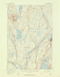
 1988 Howland1988 Print · USGSThe riverfront villages of Penobscot County are shown here in the late eighties as centers of local industry and transit. Genealogists and historians can trace the West Enfield Dam, the ridge of the Horseback, and the old Drive-In Theater.
 - 1988 Map of Seboeis
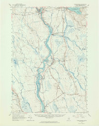
 1988 Seboeis1988 Print · USGSThe confluence of the Penobscot and Piscataquis rivers serves as the focal point for this late-century survey of central Maine. Researchers can trace the landscape from Howland north through Seboeis Stream and find sites like the Cem and Whitney Ridge.
End of results
Showing maps 1-22 of 22
Top cities near Howland
- Lincoln historical maps
- Milford historical maps
- Milo historical maps
- Enfield historical maps
- Greenbush historical maps
- Hudson historical maps
See more
Frequently asked questions
- What are the different types of historical maps available for Howland?
- What is the oldest map of Howland?
- Where can I purchase historical maps of Howland for my home or office?
- Where can I download high-res historical maps of Howland?
- Are there historical topographic maps available for Howland?
- Is there historical aerial imagery available for Howland?
- Where are historical maps of Howland sourced from?