1980s Maps of Levant, Maine
Explore 5 historic maps of Levant from the 1980s. These maps offer a rare glimpse into what life looked like during the 1980s — showing old roads, neighborhoods, homes, and landmarks that have changed or disappeared over time.
Whether you're researching your family's past, planning a metal detecting trip, or studying how Levant's landscape evolved across the 1980s, these high-resolution maps are a powerful tool for exploring the history of this region.
- Focus on a specific era: All maps on this page are from the 1980s, giving you a focused view of this time period.
- See what’s changed: Compare century-old streets, trails, and buildings to today's modern landscape using overlays and satellite layers.
- Research with precision: Use these maps for genealogy, historical research, land use analysis, or educational projects.
- View, download, or print: Maps are fully viewable online in high resolution, and can be downloaded or printed for your own records.
Start exploring Levant's history through authentic maps from the 1980s. This is your window into the past.
Levant, ME maps
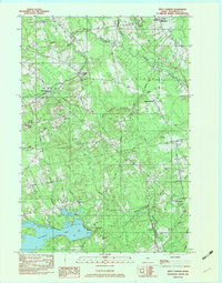
(5)- 1981 Map of West Corinth, 1982 Print
 1981 West Corinth1982 Print · USGSPenobscot County agriculture and small-town life are preserved in this early 1980s survey of the Corinth and Exeter area. Researchers can trace family history through local landmarks like Exeter Mills, the Morrison Sch, and the Corinthian Cem near East Corinth.
 - 1982 Map of West Corinth, 1983 Print
 1982 West Corinth1983 Print · USGSPenobscot County at the dawn of the eighties remains a landscape of quiet rural townships and family cemeteries. Genealogists can trace property roots near Exeter Mills, locate the Morrison Sch, or find ancestral plots at Corinthian Cem and Osgood Cem.2 unique versions available
 - 1982 Map of Carmel, 1983 Print
 1982 Carmel1983 Print · USGSPenobscot County's rural townships are shown here in the early eighties as the local landscape balanced small-town life with seasonal recreation. Genealogists and local historians can locate family plots at Highland Cem, trace the settlement at Damascus, or find old landmarks like Ring Hill Airport.2 unique versions available
 - 1985 Map of Bangor
 1985 Bangor1985 Print · USGSMid-Maine during the mid-eighties centers on the industrial pulse of the Penobscot River and its critical rail connections. Genealogists and historians can trace the development of river towns from Old Town to Ellsworth and locate regional landmarks like Fort Knox State Park.
 - 1985 Map of Skowhegan, 1986 Print
 1985 Skowhegan1986 Print · USGSCentral Maine in the mid-eighties shows a landscape of river-driven industry and rural crossroads. Genealogists can trace family names and farmsteads near Lake George or along the Maine Central Railroad through Pittsfield and Burnham.2 unique versions available
End of results
Showing maps 1-5 of 5
Top cities near Levant
- Bangor historical maps
- Orono historical maps
- Brewer historical maps
- Hampden historical maps
- Old Town historical maps
- Hermon historical maps
See more
Top neighborhoods of Levant
Frequently asked questions
- What are the different types of historical maps available for Levant?
- What is the oldest map of Levant?
- Where can I purchase historical maps of Levant for my home or office?
- Where can I download high-res historical maps of Levant?
- Are there historical topographic maps available for Levant?
- Is there historical aerial imagery available for Levant?
- Where are historical maps of Levant sourced from?