1970s Maps of T8 R7 WELS, Maine
Explore 4 historic maps of T8 R7 WELS from the 1970s. These maps offer a rare glimpse into what life looked like during the 1970s — showing old roads, neighborhoods, homes, and landmarks that have changed or disappeared over time.
Whether you're researching your family's past, planning a metal detecting trip, or studying how T8 R7 WELS's landscape evolved across the 1970s, these high-resolution maps are a powerful tool for exploring the history of this region.
- Focus on a specific era: All maps on this page are from the 1970s, giving you a focused view of this time period.
- See what’s changed: Compare century-old streets, trails, and buildings to today's modern landscape using overlays and satellite layers.
- Research with precision: Use these maps for genealogy, historical research, land use analysis, or educational projects.
- View, download, or print: Maps are fully viewable online in high resolution, and can be downloaded or printed for your own records.
Start exploring T8 R7 WELS's history through authentic maps from the 1970s. This is your window into the past.
T8 R7 WELS, ME maps
(4)- 1975 Map of Grand Lake Seboeis SE, 1981 Print
 1975 Grand Lake Seboeis SE1981 Print · USGSPenobscot County in the mid-1970s is shown in this detailed orthophotoquad, documenting the deep Maine woods and its working waterways. Trace the network of timber roads and drainage patterns around La Pomkeag Lake, Carey Lake, and Snowshoe Lake.
 - 1975 Map of Grand Lake Seboeis NW, 1981 Print
 1975 Grand Lake Seboeis NW1981 Print · USGSAroostook County in the mid-1970s is revealed through this detailed orthophoto of the deep Maine woods and its winding river systems. Researchers can trace the path of the Aroostook River and locate remote features like Chandler Lake and Mooseleuk Mountain.
 - 1975 Map of Grand Lake Seboeis SW, 1981 Print
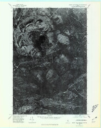
 1975 Grand Lake Seboeis SW1981 Print · USGSThe Maine timberlands near the height of the mid-seventies logging era are revealed in this detailed orthophotograph. Researchers can trace the winding shores of Grand Lake Seboeis and identify peaks like Wadleigh Mountain and Spoon Mountain.
 - 1975 Map of Grand Lake Seboeis NE, 1981 Print
 1975 Grand Lake Seboeis NE1981 Print · USGSNorthern Maine forests and the Aroostook River are captured in high-contrast detail during the mid-seventies. Trace the roads and riverside clearings near Oxbow to see the actual footprint of timber operations and local settlement at that time.
End of results
Showing maps 1-4 of 4
Top cities near T8 R7 WELS
- Ashland historical maps
- Masardis historical maps
- Mount Chase historical maps
- Garfield Plantation historical maps
- Hersey historical maps
- Oxbow historical maps
See more
Frequently asked questions
- What are the different types of historical maps available for T8 R7 WELS?
- What is the oldest map of T8 R7 WELS?
- Where can I purchase historical maps of T8 R7 WELS for my home or office?
- Where can I download high-res historical maps of T8 R7 WELS?
- Are there historical topographic maps available for T8 R7 WELS?
- Is there historical aerial imagery available for T8 R7 WELS?
- Where are historical maps of T8 R7 WELS sourced from?