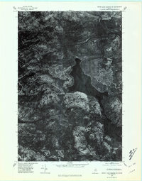
1975 Map of Grand Lake Seboeis SW
USGS Topo · Published 1981About this map
Grand Lake Seboeis dominates this aerial orthophotograph, captured in the mid-1970s. This specific type of survey combines the visual detail of aerial photography with the geometric accuracy of a topographic map, revealing the dense forest canopy and intricate drainage patterns of the Maine woods. The shoreline of the lake twists through the landscape, flanked by high ground at Spoon Mountain to the east and the area marked Cunningham further south. Smaller bodies of water including Sawtelle Pond and the northern edge of Snowshoe Lake are visible, connected by narrow streams and logging tracks that appear as thin, light veins through the timberland. To the north, the elevation rises toward Wadleigh Mountain, illustrating the remote and water-heavy geography of this portion of Penobscot County.
Find a feature on this map
6 named features on this map. Tap any name to fly to it.
Don’t see what you’re looking for? This feature index may not catch every label — zoom into the map to look around manually.
Map Details
Editions of this 1975 Grand Lake Seboeis SW Map
This is the sole edition of this map. No revisions or reprints were ever made.
Other maps of this area

1954 · Shin Pond
USGS Topo · 1:62,500

1954 · Millinocket Lake
USGS Topo · 1:62,500

1954 · Grand Lake Seboeis
USGS Topo · 1:62,500

1954 · Presque Isle
USGS Topo · 1:250,000

1955 · Traveler Mountain
USGS Topo · 1:62,500

1958 · Presque Isle
USGS Topo · 1:250,000

1960 · Presque Isle
USGS Topo · 1:250,000
1975 · Shin Pond NE
USGS Topo · 1:24,000
1975 · Shin Pond NW
USGS Topo · 1:24,000
1975 · Grand Lake Seboeis SE
USGS Topo · 1:24,000