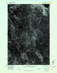
1975 Map of Shin Pond NW
USGS Topo · Published 1980About this map
Seboeis Farm sits as a lonely human outpost in this dense Maine forest, as captured by a 1975 aerial orthophotoquad. The landscape is dominated by the dark waters of Seboeis Lake and the rising elevation of Snowshoe Mtn in the northern portion of the quadrangle. Unlike traditional topographic maps, this imagery-based study provides a direct look at the timber density and the intricate network of logging roads and trails that defined the region's mid-century wilderness economy. The absence of larger settlements highlights the isolation of this part of Penobscot County, where water and wood were the primary features of interest for the Usgs mappers.
Find a feature on this map
3 named features on this map. Tap any name to fly to it.
Don’t see what you’re looking for? This feature index may not catch every label — zoom into the map to look around manually.
Map Details
Editions of this 1975 Shin Pond NW Map
This is the sole edition of this map. No revisions or reprints were ever made.
Other maps of this area

1954 · Shin Pond
USGS Topo · 1:62,500

1954 · Millinocket Lake
USGS Topo · 1:62,500

1954 · Grand Lake Seboeis
USGS Topo · 1:62,500

1954 · Presque Isle
USGS Topo · 1:250,000

1955 · Traveler Mountain
USGS Topo · 1:62,500

1958 · Presque Isle
USGS Topo · 1:250,000

1960 · Presque Isle
USGS Topo · 1:250,000
1975 · The Traveler
USGS Topo · 1:24,000
1975 · Shin Pond NE
USGS Topo · 1:24,000
1975 · Shin Pond SW
USGS Topo · 1:24,000