1980s Maps of East Middlesex Canal Grant Township, Maine
Explore 7 historic maps of East Middlesex Canal Grant Township from the 1980s. These maps offer a rare glimpse into what life looked like during the 1980s — showing old roads, neighborhoods, homes, and landmarks that have changed or disappeared over time.
Whether you're researching your family's past, planning a metal detecting trip, or studying how East Middlesex Canal Grant Township's landscape evolved across the 1980s, these high-resolution maps are a powerful tool for exploring the history of this region.
- Focus on a specific era: All maps on this page are from the 1980s, giving you a focused view of this time period.
- See what’s changed: Compare century-old streets, trails, and buildings to today's modern landscape using overlays and satellite layers.
- Research with precision: Use these maps for genealogy, historical research, land use analysis, or educational projects.
- View, download, or print: Maps are fully viewable online in high resolution, and can be downloaded or printed for your own records.
Start exploring East Middlesex Canal Grant Township's history through authentic maps from the 1980s. This is your window into the past.
East Middlesex Canal Grant Township, ME maps
(7)- 1985 Map of Moosehead Lake, 1986 Print
 1985 Moosehead Lake1986 Print · USGSThe Maine North Woods in the 1980s remain a landscape of vast timberlands, railroads, and the sprawling waters of the state's largest lake. Researchers can trace the Canadian Pacific line through Rockwood or locate historical townships from Seboomook to Kokadjo.
 - 1988 Map of Big Spencer Mtn
 1988 Big Spencer Mtn1988 Print · USGSThe Maine North Woods are captured here in the late 1980s, an era of active timber management and remote wilderness surveying. Researchers can locate the Fire Lookout Tower atop Big Spencer Mtn and trace the boundaries of the East Middlesex Canal Grant.2 unique versions available
 - 1988 Map of Kokadjo
 1988 Kokadjo1988 Print · USGSThe settlement of Kokadjo is captured in the late eighties at its historic position between First Roach Pond and the Roach River. Local historians can trace the Dam and several Sand and Gravel Pits amid the townships of Frenchtown and Spencer Bay.
 - 1989 Map of Spencer Bay
 1989 Spencer Bay1989 Print · USGSMoosehead Lake and the surrounding Maine timberlands are captured here in the late 1980s. Sportsmen and researchers can trace the shoreline from Jewett Cove to Stevens Pt, locating specific campsites and the path of the Roach River.
 - 1989 Map of Mount Kineo
 1989 Mount Kineo1989 Print · USGSThe eastern shores of Moosehead Lake are documented here in the late eighties, just as the region maintained its reputation for outdoor recreation and timber. Genealogists and researchers can locate old tracts like the Days Academy Grant and the Deer Head Farm.2 unique versions available
 - 1989 Map of North East Carry
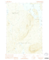
 1989 North East Carry1989 Print · USGSThe northern reaches of Moosehead Lake are captured in the late 1980s, showcasing the traditional land grants and portage points of the Maine woods. Researchers can trace historical boundaries like the East Middlesex Canal Grant or locate specific sites like Folsom Farm and North East Carry.
 - 1989 Map of Lobster Mountain
 1989 Lobster Mountain1989 Print · USGSMaine's North Woods are documented here in the late twentieth century, showing a landscape of glacial lakes and historic canal grants. Researchers can trace land divisions in the East Middlesex Canal Grant or explore the shores of Lobster Lake near Big Island.2 unique versions available
End of results
Showing maps 1-7 of 7
Top cities near East Middlesex Canal Grant Township
Frequently asked questions
- What are the different types of historical maps available for East Middlesex Canal Grant Township?
- What is the oldest map of East Middlesex Canal Grant Township?
- Where can I purchase historical maps of East Middlesex Canal Grant Township for my home or office?
- Where can I download high-res historical maps of East Middlesex Canal Grant Township?
- Are there historical topographic maps available for East Middlesex Canal Grant Township?
- Is there historical aerial imagery available for East Middlesex Canal Grant Township?
- Where are historical maps of East Middlesex Canal Grant Township sourced from?