Old Maps of T3 R11 WELS, Maine
Explore 34 old maps of T3 R11 WELS, spanning from 1954 to today. These high-resolution historic maps reveal how streets, neighborhoods, landmarks, and natural features evolved over time — perfect for genealogy, metal detecting, research, and local history exploration.
What you can do with these maps:
- See how T3 R11 WELS changed over time: Compare historical maps to modern-day views to trace roads, homesites, rail lines & more.
- View detailed metadata: Each map includes creators, publishers, year, scale, and archive source.
- Overlay maps with satellite & LiDAR: Visualize the past alongside modern tools to explore terrain & human change.
- Trusted historical sources: Maps sourced from the USGS, Library of Congress, and other archives.
- Access maps your way: View online, download high-res files, or order prints for personal or research use.
Start exploring old maps of T3 R11 WELS to uncover forgotten places, hidden landmarks, and the deep history beneath your feet.
T3 R11 WELS, ME maps
(34)- 1954 Map of Harrington Lake, 1956 Print
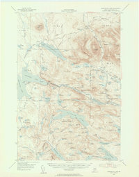 1954 Harrington Lake1956 Print · USGSThe North Woods of the 1950s come alive in this survey of the Penobscot river system and its rugged interior peaks. Trace the early path of the Appalachian Trail past Rainbow Lake or locate the infrastructure at Ripogenus Dam and the Forest Service Camp.5 unique versions available
 - 1954 Map of Millinocket, 1968 Print
 1954 Millinocket1968 Print · USGSMaine's North Woods and the Penobscot Valley are captured here during the mid-century era of logging and rail dominance. You can trace the path of the Bangor and Aroostook Railroad through timber towns like Millinocket, Mattawamkeag, and Silver Ridge.3 unique versions available
 - 1958 Map of Millinocket
 1958 Millinocket1958 Print · USGSMaine's North Woods and the Penobscot river valley are captured here in the mid-1950s, showing a landscape of timber, rail, and wild waters. Researchers can trace the legacy of the Canadian Pacific railroad and find historic settlements like Millinocket, Sherman Station, and Mattawamkeag.
 - 1960 Map of Millinocket
 1960 Millinocket1960 Print · USGSThe Maine North Woods and Penobscot River valley are captured at mid-century during the height of the paper milling era. Researchers can trace the Appalachian Trail near Mount Katardin or locate family roots in towns like Dover-Foxcroft and Milo.3 unique versions available
 - 1978 Map of Rainbow Lake West, 1981 Print
 1978 Rainbow Lake West1981 Print · USGSPiscataquis County timberlands and remote waters are seen here in the late seventies through direct aerial photography. Researchers can trace the wild shorelines of Rainbow Lake, Nahmakanta Lake, and the secluded Pollywog Pond.
 - 1978 Map of Harrington Lake, 1981 Print
 1978 Harrington Lake1981 Print · USGSThe North Maine Woods are captured in the late seventies, showing the vital waterways and timberlands around Harrington Lake. Researchers can trace the engineering of Chesuncook Dam and the shoreline of the West Branch Penobscot River during a period of active forest management.
 - 1978 Map of Rainbow Lake East, 1981 Print
 1978 Rainbow Lake East1981 Print · USGSPiscataquis County's deep woods and glacial waters are captured in this late-seventies aerial study of the Maine wilderness. Researchers can trace the rugged shoreline of Rainbow Lake and the winding course of the West Branch Penobscot River.
 - 1978 Map of Doubletop Mountain, 1981 Print
 1978 Doubletop Mountain1981 Print · USGSThe Maine wilderness in the late seventies is seen through this orthophotograph of the high peaks in Piscataquis County. Researchers can study the untouched drainage of Nesowadnehunk Stream or locate landmarks like Doubletop Mountain and Kidney Pond.
 - 1985 Map of Moosehead Lake, 1986 Print
 1985 Moosehead Lake1986 Print · USGSThe Maine North Woods in the 1980s remain a landscape of vast timberlands, railroads, and the sprawling waters of the state's largest lake. Researchers can trace the Canadian Pacific line through Rockwood or locate historical townships from Seboomook to Kokadjo.
 - 1988 Map of Rainbow Lake West
 1988 Rainbow Lake West1988 Print · USGSThe Maine backcountry of the late 1980s is captured here in a region shaped by glacial lakes and the legendary Appalachian National Scenic Trail. Trace the rugged path from Rainbow Lake past Nesuntabunt Mtn and the remote Pollywog Pond.2 unique versions available
 - 1988 Map of Rainbow Lake East
 1988 Rainbow Lake East1988 Print · USGSPiscataquis County's deep woods and river systems are documented here in the late eighties, just south of the Great Northern Paper Company lands. Hikers and historians can trace the Appalachian National Scenic Trail as it skirts Rainbow Lake and passes Sentinel Mtn.
 - 1988 Map of Harrington Lake
 1988 Harrington Lake1988 Print · USGSThe Maine North Woods in the late twentieth century is a landscape of timber tracts and managed water. Trace the hydraulic network from Ripogenus Dam to Harrington Lake, locating landmarks like Soubunge Mountain and Ripogenus Gorge.
 - 1988 Map of Doubletop Mountain
 1988 Doubletop Mountain1988 Print · USGSBaxter State Park in the late 1980s reveals a pristine landscape of high peaks and protected wilderness. Trace the legendary Appalachian National Scenic Trail as it passes Kidney Pond and Katahdin Stream Campground beneath the shadow of Doubletop Mountain.2 unique versions available
 - 1994 Map of Moosehead Lake
 1994 Moosehead Lake1994 Print · USGSThe Maine North Woods at the end of the twentieth century remains a landscape of vast timberlands and remote outposts. Researchers can trace the Appalachian National Scenic Trail and locate historic water controls like Chesuncook Dam and Ripogenus Dam.
 - 2011 Map of Rainbow Lake East, 2011 Print
 2011 Rainbow Lake East2011 Print · USGSCovers T3 R11 WELS, including T1 R10 WELS, T2 R10 WELS, and other nearby areas
 - 2011 Map of Rainbow Lake West, 2011 Print
 2011 Rainbow Lake West2011 Print · USGSCovers T3 R11 WELS, including T1 R12 WELS, Rainbow Township, and other nearby areas
 - 2011 Map of Doubletop Mountain, 2011 Print
 2011 Doubletop Mountain2011 Print · USGSCovers T3 R11 WELS, including T4 R11 WELS, T3 R10 WELS, and other nearby areas
 - 2011 Map of Harrington Lake, 2011 Print
 2011 Harrington Lake2011 Print · USGSCovers T3 R11 WELS, including T4 R11 WELS, T4 R12 WELS, and other nearby areas
 - 2014 Map of Rainbow Lake West, 2014 Print
 2014 Rainbow Lake West2014 Print · USGSCovers T3 R11 WELS, including T1 R12 WELS, Rainbow Township, and other nearby areas
 - 2014 Map of Harrington Lake, 2014 Print
 2014 Harrington Lake2014 Print · USGSCovers T3 R11 WELS, including T4 R11 WELS, T4 R12 WELS, and other nearby areas
 - 2014 Map of Rainbow Lake East, 2014 Print
 2014 Rainbow Lake East2014 Print · USGSCovers T3 R11 WELS, including T1 R10 WELS, T2 R10 WELS, and other nearby areas
 - 2014 Map of Doubletop Mountain, 2014 Print
 2014 Doubletop Mountain2014 Print · USGSCovers T3 R11 WELS, including T4 R11 WELS, T3 R10 WELS, and other nearby areas
 - 2018 Map of Rainbow Lake East, 2018 Print
 2018 Rainbow Lake East2018 Print · USGSCovers T3 R11 WELS, including T1 R10 WELS, T2 R10 WELS, and other nearby areas
 - 2018 Map of Rainbow Lake West, 2018 Print
 2018 Rainbow Lake West2018 Print · USGSCovers T3 R11 WELS, including T1 R12 WELS, Rainbow Township, and other nearby areas
 - 2018 Map of Doubletop Mountain, 2018 Print
 2018 Doubletop Mountain2018 Print · USGSCovers T3 R11 WELS, including T4 R11 WELS, T3 R10 WELS, and other nearby areas
Showing maps 1-25 of 34
Frequently asked questions
- What are the different types of historical maps available for T3 R11 WELS?
- What is the oldest map of T3 R11 WELS?
- Where can I purchase historical maps of T3 R11 WELS for my home or office?
- Where can I download high-res historical maps of T3 R11 WELS?
- Are there historical topographic maps available for T3 R11 WELS?
- Is there historical aerial imagery available for T3 R11 WELS?
- Where are historical maps of T3 R11 WELS sourced from?