1980s Maps of T5 R9 WELS, Maine
Explore 4 historic maps of T5 R9 WELS from the 1980s. These maps offer a rare glimpse into what life looked like during the 1980s — showing old roads, neighborhoods, homes, and landmarks that have changed or disappeared over time.
Whether you're researching your family's past, planning a metal detecting trip, or studying how T5 R9 WELS's landscape evolved across the 1980s, these high-resolution maps are a powerful tool for exploring the history of this region.
- Focus on a specific era: All maps on this page are from the 1980s, giving you a focused view of this time period.
- See what’s changed: Compare century-old streets, trails, and buildings to today's modern landscape using overlays and satellite layers.
- Research with precision: Use these maps for genealogy, historical research, land use analysis, or educational projects.
- View, download, or print: Maps are fully viewable online in high resolution, and can be downloaded or printed for your own records.
Start exploring T5 R9 WELS's history through authentic maps from the 1980s. This is your window into the past.
T5 R9 WELS, ME maps
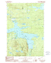
(4)- 1985 Map of Oakfield
 1985 Oakfield1985 Print · USGSAroostook County in the 1980s displays a balance between the timber-and-rail industry and the protected wilderness of the North Woods. Genealogists and local historians can trace family-named hubs like Smyrna Mills, Island Falls, and Knowles Corner along the Bangor and Aroostook railroad line.
 - 1988 Map of Frost Pond
 1988 Frost Pond1988 Print · USGSBaxter State Park and the northern Maine wilderness are documented here in the late eighties, showing the region's complex lake systems and river portages. Trace the historic Indian Carry along Webster Brook or locate sites like Trout Brook Crossing.
 - 1988 Map of Trout Brook Mtn
 1988 Trout Brook Mtn1988 Print · USGSBaxter State Park and the surrounding wildlands in the late eighties show a landscape shaped by logging history and conservation. Genealogists and historians can locate remote outposts like Trout Brook Farm and infrastructure including Norway Dam and Grand Lake Dam.2 unique versions available
 - 1988 Map of Wassataquoik Lake
 1988 Wassataquoik Lake1988 Print · USGSBaxter State Park in the late eighties presents a wilderness of glacial lakes and mountain ridges preserved in its primitive state. Outdoor historians can trace the paths between POGY NOTCH and Six Ponds, or locate landmarks like Black Brook Farm and Inscription Rock.
End of results
Showing maps 1-4 of 4
Frequently asked questions
- What are the different types of historical maps available for T5 R9 WELS?
- What is the oldest map of T5 R9 WELS?
- Where can I purchase historical maps of T5 R9 WELS for my home or office?
- Where can I download high-res historical maps of T5 R9 WELS?
- Are there historical topographic maps available for T5 R9 WELS?
- Is there historical aerial imagery available for T5 R9 WELS?
- Where are historical maps of T5 R9 WELS sourced from?