1950s Maps of Bradstreet Township, Maine
Explore 3 historic maps of Bradstreet Township from the 1950s. These maps offer a rare glimpse into what life looked like during the 1950s — showing old roads, neighborhoods, homes, and landmarks that have changed or disappeared over time.
Whether you're researching your family's past, planning a metal detecting trip, or studying how Bradstreet Township's landscape evolved across the 1950s, these high-resolution maps are a powerful tool for exploring the history of this region.
- Focus on a specific era: All maps on this page are from the 1950s, giving you a focused view of this time period.
- See what’s changed: Compare century-old streets, trails, and buildings to today's modern landscape using overlays and satellite layers.
- Research with precision: Use these maps for genealogy, historical research, land use analysis, or educational projects.
- View, download, or print: Maps are fully viewable online in high resolution, and can be downloaded or printed for your own records.
Start exploring Bradstreet Township's history through authentic maps from the 1950s. This is your window into the past.
Bradstreet Township, ME maps
(3)- 1950 Map of Attean
 1950 Attean1950 Print · USGSSomerset County’s northern timberlands and the Canadian border are captured here at mid-century, when the railroad remained the primary artery. Researchers can locate the old Stetson Sch, the remote Boston Ranch, and the railway hub at Jackman Station.2 unique versions available
 - 1958 Map of Spencer Lake, 1960 Print
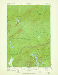
 1958 Spencer Lake1960 Print · USGSSomerset County’s remote wilderness is documented here in the late fifties, showing a landscape shaped by the timber and sporting industries. Researchers can locate specific seasonal outposts like Hobbstown Depot Camp, Kibby Kamp, and the Spencer Dam.3 unique versions available
 - 1958 Map of Pierce Pond, 1960 Print
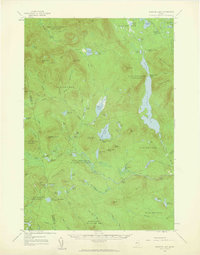
 1958 Pierce Pond1960 Print · USGSSomerset County's remote townships and river corridors are meticulously charted during the mid-century peak of the Maine sporting camp tradition. Researchers can locate established backcountry sites like Grace Pond Camp, the fields of Salmon Stream Farm, and the waters of Enchanted Pond.3 unique versions available
End of results
Showing maps 1-3 of 3
Top cities near Bradstreet Township
- Jackman historical maps
- Moose River historical maps
- Dennistown Plantation historical maps
- West Forks historical maps
- The Forks historical maps
Top neighborhoods of Bradstreet Township
Frequently asked questions
- What are the different types of historical maps available for Bradstreet Township?
- What is the oldest map of Bradstreet Township?
- Where can I purchase historical maps of Bradstreet Township for my home or office?
- Where can I download high-res historical maps of Bradstreet Township?
- Are there historical topographic maps available for Bradstreet Township?
- Is there historical aerial imagery available for Bradstreet Township?
- Where are historical maps of Bradstreet Township sourced from?