1900s (20th Century) Maps of Norridgewock, Maine
Explore 25 historic maps of Norridgewock from the 1900s (20th Century). These maps offer a rare glimpse into what life looked like during the 1900s — showing old roads, neighborhoods, homes, and landmarks that have changed or disappeared over time.
Whether you're researching your family's past, planning a metal detecting trip, or studying how Norridgewock's landscape evolved across the 1900s, these high-resolution maps are a powerful tool for exploring the history of this region.
- Focus on a specific era: All maps on this page are from the 1900s, giving you a focused view of this time period.
- See what’s changed: Compare century-old streets, trails, and buildings to today's modern landscape using overlays and satellite layers.
- Research with precision: Use these maps for genealogy, historical research, land use analysis, or educational projects.
- View, download, or print: Maps are fully viewable online in high resolution, and can be downloaded or printed for your own records.
Start exploring Norridgewock's history through authentic maps from the 1900s. This is your window into the past.
Norridgewock, ME maps
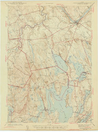
(25)- 1904 Map of Anson
 1904 Anson1904 Print · USGSSomerset County is shown in the early 1900s as a thriving corridor of river industry and rail transport. Genealogists can trace family landmarks like Savage Hill or locate early centers such as Twelve Corners, North Anson, and the island-studded Kennebec River.4 unique versions available
 - 1913 Map of Skowhegan
 1913 Skowhegan1913 Print · USGSSomerset County thrives as a hub of rail and river industry in this pre-war survey. Genealogists can trace family names through dozens of rural landmarks like Malbons Mills, the Union Church, and neighborhood schoolhouses from Athens to Canaan.4 unique versions available
 - 1943 Map of Norridgewock
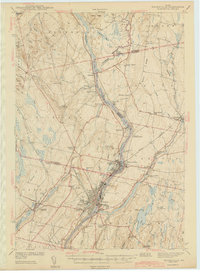
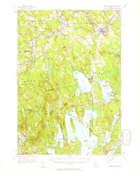
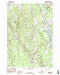
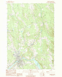
 1943 Norridgewock1943 Print · USGSSomerset and Kennebec counties are shown here just after the start of the war, when the Maine Central railroad still connected these rural river towns. Researchers can locate specific family landmarks including the Whitehouse Cem, Hersom Sch, and the Norridgewock Rearing Pool.3 unique versions available
 - 1943 Map of Waterville
 1943 Waterville1943 Print · USGSThe Kennebec and Sebasticook river valleys are shown in detail during the early 1940s, highlighting the rail hubs of Waterville and Winslow. Genealogists can trace family landmarks like Pratt Cem or the rural Covell Sch and Ten Lots Chapel.2 unique versions available
 - 1948 Map of Bangor
 1948 Bangor1948 Print · USGSThe Maine coast and its industrial river valleys are captured here shortly after the war, showing the vital shipping and rail hubs of the late 1940s. Genealogists and historians can trace the tracks of the Maine Central RR connecting Bangor, Augusta, and Old Town.
 - 1955 Map of Anson, 1957 Print
 1955 Anson1957 Print · USGSThe Kennebec River valley in the mid-1950s shows a landscape of busy riverside towns and quiet rural crossroads. Researchers can trace the Maine Central Railroad and find local landmarks like the Union Ch, Purington Sch, and the uniquely named Land of Rest Cem.4 unique versions available
 - 1955 Map of Skowhegan, 1958 Print
 1955 Skowhegan1958 Print · USGSSomerset County in the mid-fifties shows a landscape of busy river towns and rural school districts connected by the Maine Central railroad. Genealogists can trace family names through landmarks like Malbons Mills, Cass Corner, and the Somerset Academy.4 unique versions available
 - 1956 Map of Norridgewock, 1958 Print
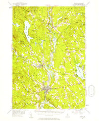
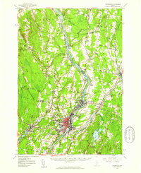
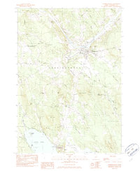
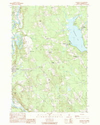
 1956 Norridgewock1958 Print · USGSSomerset and Kennebec counties are shown here in the mid-1950s, centered on the river convergence at Norridgewock. Genealogists and historians can trace local school districts like Whittier Sch and explore lakefront landmarks including Camp Abena and The Serpentine.3 unique versions available
 - 1956 Map of Bangor, 1966 Print
 1956 Bangor1966 Print · USGSMid-century Maine comes alive in this survey of the rugged coast and river valleys during the 1950s. Genealogists and historians can trace the vital rail corridors of the Maine Central RR connecting timber towns like Old Town to the coast at Bar Harbor.3 unique versions available
 - 1957 Map of Waterville, 1959 Print
 1957 Waterville1959 Print · USGSThe Kennebec River valley in the late fifties shows a bustling industrial landscape centered on the rail-and-river hub of Waterville. Researchers can trace historic institutions like Colby College, the Central Maine Sanatorium, and family-named sites such as Pishon Ferry or Ten Lots Chapel.3 unique versions available
 - 1960 Map of Bangor
 1960 Bangor1960 Print · USGSCentral Maine in the sixties reveals a landscape of river-powered industry and sprawling coastal island chains. Researchers can trace the rail corridors of the Maine Central or locate mid-century aviation landmarks like Dow Air Force Base.
 - 1961 Map of Bangor
 1961 Bangor1961 Print · USGSMid-century Maine comes alive through its busy river ports and rocky archipelagoes during a period of steady maritime and rail commerce. Researchers can trace the path of the Maine Central railroad and locate coastal landmarks from Acadia National Park to Vinalhaven Island.
 - 1975 Map of Norridgewock NE, 1980 Print
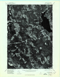
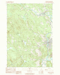
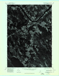 1975 Norridgewock NE1980 Print · USGSSomerset County's riverfront and woodlands are captured here in the mid-seventies, showing the intersection of rural life and the Kennebec River. Trace land use patterns near Norridgewock, the rise of Mount Tom, and the shorelines of North Pond.
 - 1975 Map of Skowhegan SW, 1980 Print
 1975 Skowhegan SW1980 Print · USGSSkowhegan and the Kennebec River valley are captured in this mid-seventies aerial survey of central Maine. Trace the historical footprints of industrial sites like Malbons Mills and Lower Mill or the shoreline of Wesserunsett Lake.
 - 1975 Map of Anson SE, 1980 Print
 1975 Anson SE1980 Print · USGSSomerset County land and river patterns are captured in high detail in the mid-1970s. Researchers can trace the winding Kennebec River and identify family-named crossroads like Blackwell Corner and Martin Corner.
 - 1975 Map of Waterville NW, 1980 Print
 1975 Waterville NW1980 Print · USGSNorth Fairfield and the Kennebec River valley are captured in the mid-seventies just as the rural landscape of central Maine was entering a new era of growth. Local historians can trace the footprint of crossroads settlements like Holway Corner and the riverfront community of Hinckley.
 - 1975 Map of Norridgewock NW, 1980 Print
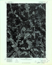
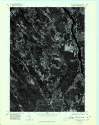
 1975 Norridgewock NW1980 Print · USGSCentral Maine in the mid-seventies is revealed through this detailed orthophoto of the winding Sandy River valley. Genealogists and historians can trace the rural layouts of Starks and Mercer or locate homesteads along Bog Stream.
 - 1976 Map of Anson SW, 1980 Print
 1976 Anson SW1980 Print · USGSSomerset County river settlements and timberlands are captured in this mid-seventies aerial study. Trace the industrial and residential footprints along the Kennebec River through Anson, North Anson, and Madison.
 - 1982 Map of Norridgewock
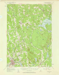
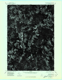
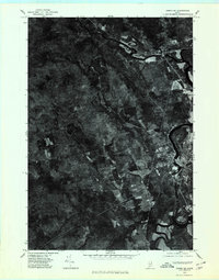
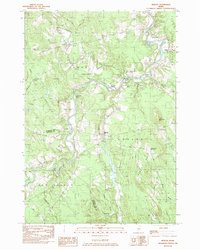
 1982 Norridgewock1982 Print · USGSSomerset County's riverfront and upland terrain are documented here in the early eighties, capturing the area's development and natural hydrology. Genealogists and local historians can locate family landmarks like Ross Hill, rural cemeteries such as Gould Cem, and former school sites including Central Sch.2 unique versions available
 - 1982 Map of Hinckley
 1982 Hinckley1982 Print · USGSThe Kennebec River corridor comes into focus in the early 1980s as it winds past the hills of Somerset and Kennebec counties. Genealogists and local historians can trace family burial sites like Tozier Cem and landmarks such as the Hinckley Home Farm Sch.
 - 1982 Map of Mercer, 1983 Print
 1982 Mercer1983 Print · USGSSomerset County's rural river valleys are shown in detail during the late twentieth century as traditional crossroads communities remained the focus of local life. Researchers can locate family burial sites like Hampshire Hill Cem or trace the early footprint of Beech Hill Airport and Starks Ch.
 - 1985 Map of Skowhegan, 1986 Print
 1985 Skowhegan1986 Print · USGSCentral Maine in the mid-eighties shows a landscape of river-driven industry and rural crossroads. Genealogists can trace family names and farmsteads near Lake George or along the Maine Central Railroad through Pittsfield and Burnham.2 unique versions available
 - 1989 Map of Madison West
 1989 Madison West1989 Print · USGSThe Kennebec and Carrabassett rivers meet in this 1980s Somerset County survey during a period of enduring rural industry and traditional riverfront settlement. Researchers can trace historical routes like the Arnold Trail and locate family landmarks such as Pease Corner, Savage Island, and Dane Corner.
 - 1989 Map of Skowhegan
 1989 Skowhegan1989 Print · USGSThe Kennebec River valley in the late 1980s shows a landscape of river-bend industry and upland ridges. Researchers can locate specific local landmarks such as Malbons Mills, the Drive-In Theater, and the historic Old Belgrade Grade.
 - 1989 Map of Madison East
 1989 Madison East1989 Print · USGSSomerset County's river valleys and lakefronts are captured here in the late 1980s, showcasing the transition from the Kennebec River to Wesserunset Lake. Researchers can trace old crossroads like White School Corner or locate family landmarks on Eames Hill and Tarbell Hill.
End of results
Showing maps 1-25 of 25
Top cities near Norridgewock
- Waterville historical maps
- Winslow historical maps
- Fairfield historical maps
- Skowhegan historical maps
- Oakland historical maps
- Madison historical maps
See more
Top neighborhoods of Norridgewock
Frequently asked questions
- What are the different types of historical maps available for Norridgewock?
- What is the oldest map of Norridgewock?
- Where can I purchase historical maps of Norridgewock for my home or office?
- Where can I download high-res historical maps of Norridgewock?
- Are there historical topographic maps available for Norridgewock?
- Is there historical aerial imagery available for Norridgewock?
- Where are historical maps of Norridgewock sourced from?