1980s Maps of Pittsfield, Maine
Explore 6 historic maps of Pittsfield from the 1980s. These maps offer a rare glimpse into what life looked like during the 1980s — showing old roads, neighborhoods, homes, and landmarks that have changed or disappeared over time.
Whether you're researching your family's past, planning a metal detecting trip, or studying how Pittsfield's landscape evolved across the 1980s, these high-resolution maps are a powerful tool for exploring the history of this region.
- Focus on a specific era: All maps on this page are from the 1980s, giving you a focused view of this time period.
- See what’s changed: Compare century-old streets, trails, and buildings to today's modern landscape using overlays and satellite layers.
- Research with precision: Use these maps for genealogy, historical research, land use analysis, or educational projects.
- View, download, or print: Maps are fully viewable online in high resolution, and can be downloaded or printed for your own records.
Start exploring Pittsfield's history through authentic maps from the 1980s. This is your window into the past.
Pittsfield, ME maps
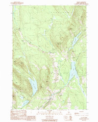
(6)- 1982 Map of Burnham, 1983 Print
 1982 Burnham1983 Print · USGSWaldo and Somerset counties come into focus in the early 1980s, centered on the river-and-rail corridor of the Sebasticook River. Researchers can trace old property lines and rural life near Burnham, Nash Corner, and the Maine Central RR line.
 - 1982 Map of Pittsfield, 1983 Print
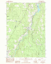
 1982 Pittsfield1983 Print · USGSCentral Maine in the early eighties shows a landscape defined by the Sebasticook River and the Maine Central railroad. Genealogists can trace family names through local landmarks like Manson Corner and Fuller Corner Cem.
 - 1982 Map of Newport, 1983 Print
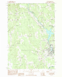
 1982 Newport1983 Print · USGSThe rural landscape of Somerset and Penobscot counties is captured here in the early eighties, showing the towns of Newport and Pittsfield along the water. Genealogists can trace family locations at Dogtown, Miles Corner, and numerous rural Cem sites.2 unique versions available
 - 1982 Map of Unity Pond, 1983 Print
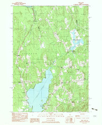 1982 Unity Pond1983 Print · USGSThe rural crossroads of Waldo and Penobscot counties are captured here in the early eighties, just as conservation efforts like the Carlton Pond Waterfowl Production Area were established. Researchers can trace numerous family-named landmarks such as Gerrish Corner, Smarts Corner, and Troy Center.2 unique versions available
 - 1985 Map of Skowhegan, 1986 Print
 1985 Skowhegan1986 Print · USGSCentral Maine in the mid-eighties shows a landscape of river-driven industry and rural crossroads. Genealogists can trace family names and farmsteads near Lake George or along the Maine Central Railroad through Pittsfield and Burnham.2 unique versions available
 - 1989 Map of Canaan
 1989 Canaan1989 Print · USGSCanaan and its surrounding Somerset County corners are captured here in the late 1980s, showcasing a landscape of glacial ponds and family-named hills. Genealogists and local historians can trace rural settlements at Mitchell Corner and Browns Corner, or locate landmarks like Jewell Hill and Sibley Pond.
End of results
Showing maps 1-6 of 6
Top cities near Pittsfield
- Waterville historical maps
- Winslow historical maps
- Fairfield historical maps
- Skowhegan historical maps
- Dexter historical maps
- Clinton historical maps
See more
Top neighborhoods of Pittsfield
- Tilton Corner historical maps
- Waverley historical maps
- Burton Corner historical maps
- Emerson Corner historical maps
- Nash Corner historical maps
- Phillips Corner historical maps
See more
Frequently asked questions
- What are the different types of historical maps available for Pittsfield?
- What is the oldest map of Pittsfield?
- Where can I purchase historical maps of Pittsfield for my home or office?
- Where can I download high-res historical maps of Pittsfield?
- Are there historical topographic maps available for Pittsfield?
- Is there historical aerial imagery available for Pittsfield?
- Where are historical maps of Pittsfield sourced from?