1980s Maps of Squaretown Township, Maine
Explore 5 historic maps of Squaretown Township from the 1980s. These maps offer a rare glimpse into what life looked like during the 1980s — showing old roads, neighborhoods, homes, and landmarks that have changed or disappeared over time.
Whether you're researching your family's past, planning a metal detecting trip, or studying how Squaretown Township's landscape evolved across the 1980s, these high-resolution maps are a powerful tool for exploring the history of this region.
- Focus on a specific era: All maps on this page are from the 1980s, giving you a focused view of this time period.
- See what’s changed: Compare century-old streets, trails, and buildings to today's modern landscape using overlays and satellite layers.
- Research with precision: Use these maps for genealogy, historical research, land use analysis, or educational projects.
- View, download, or print: Maps are fully viewable online in high resolution, and can be downloaded or printed for your own records.
Start exploring Squaretown Township's history through authentic maps from the 1980s. This is your window into the past.
Squaretown Township, ME maps
(5)- 1986 Map of Dover-Foxcroft
 1986 Dover-Foxcroft1986 Print · USGSPiscataquis County at the edge of the great Maine woods is documented here in the mid-1980s, centered on the river-and-rail hubs of the interior. Trace the industrial footprints of Dover South Mills, the rail yards at Brownville Junction, or the historic Katahdin Iron Works.
 - 1988 Map of Indian Pond South
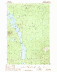
 1988 Indian Pond South1988 Print · USGSThe Kennebec River and Indian Pond are shown here in the 1980s, revealing a landscape of managed timberlands and hydroelectric infrastructure. Genealogists and local historians can locate remote landmarks like Scribner Bog, the Campground, and the Pwr Plant.
 - 1988 Map of Moxie Pond
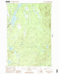
 1988 Moxie Pond1988 Print · USGSSomerset County's wilderness is captured here in the late eighties, centered on the dramatic length of Moxie Pond. Hikers and historians can trace the Appalachian National Scenic Trail as it passes Bald Mountain and the lakeside stop at Troutdale.
 - 1988 Map of Black Brook Pond
 1988 Black Brook Pond1988 Print · USGSSomerset County’s northern woods appear in the late eighties as a network of timber tracts and river drainages. Genealogists and historians can trace the borders of West Forks Plantation and search for landmarks like Cold Stream Mtn and Black Brook Pond.2 unique versions available
 - 1989 Map of Big Squaw Pond
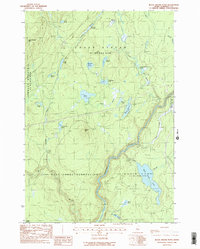
 1989 Big Squaw Pond1989 Print · USGSThe Piscataquis County woods are documented here in the late 1980s, showcasing the high ridges and deep bogs west of Greenville. Researchers can trace township boundaries and find remote water bodies like Big Squaw Pond, Ira Bog, and the shorelines of Moosehead Lake.
End of results
Showing maps 1-5 of 5
Top cities near Squaretown Township
- Greenville historical maps
- Monson historical maps
- Shirley historical maps
- Beaver Cove historical maps
- Blanchard Township historical maps
- Caratunk historical maps
See more
Frequently asked questions
- What are the different types of historical maps available for Squaretown Township?
- What is the oldest map of Squaretown Township?
- Where can I purchase historical maps of Squaretown Township for my home or office?
- Where can I download high-res historical maps of Squaretown Township?
- Are there historical topographic maps available for Squaretown Township?
- Is there historical aerial imagery available for Squaretown Township?
- Where are historical maps of Squaretown Township sourced from?