Old Maps of Starks, Maine for Hiking & Exploration
Hike through history with 49 historic maps of Starks. Explore old trails, ghost towns, and forgotten backroads — perfect for outdoor adventurers and local explorers.
- Rediscover forgotten places: Map out old mining camps, roads, and footpaths that no longer exist on modern maps.
- Layer with modern tools: Combine with LiDAR or satellite views to plan hikes through historical terrain.
- Made for exploration: Popular among hikers, overlanders, and local history lovers.
Use these maps to find adventure and explore the hidden past of Starks.
Starks, ME maps
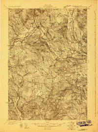
(49)- 1894 Map of Norridgewock
 1894 Norridgewock1894 Print · USGSSomerset and Kennebec counties are shown at the height of the Victorian era, characterized by an intricate network of glacial lakes and river ferries. Genealogists can trace early homesteads and transport points like Davis Ferry, Belgrade Mills, and South Norridgewock.
 - 1898 Map of Norridgewock
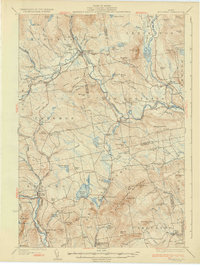
 1898 Norridgewock1898 Print · USGSSomerset and Kennebec Counties are shown here during the late Victorian era as the river-and-rail economy thrived. Genealogists can trace family holdings and old crossings like Davis Ferry, Belgrade Mills, and the historic village of Norridgewock.5 unique versions available
 - 1904 Map of Anson
 1904 Anson1904 Print · USGSSomerset County is shown in the early 1900s as a thriving corridor of river industry and rail transport. Genealogists can trace family landmarks like Savage Hill or locate early centers such as Twelve Corners, North Anson, and the island-studded Kennebec River.4 unique versions available
 - 1924 Map of Farmington
 1924 Farmington1924 Print · USGSFranklin County in the early 1920s is a landscape of river-powered mills and intersecting rail lines, including the Sandy River and Rangeley Lakes RR. Genealogists can locate dozens of country schools and rural settlements like Allens Mills and Knowltons Corner.6 unique versions available
 - 1930 Map of Kingfield
 1930 Kingfield1930 Print · USGSThe Kingfield region and the western Maine highlands are captured here in the early 1930s. Genealogists can locate family homesteads near numerous district schools like Guild Sch and Hardy Sch, or trace the old roads through New Vineyard and Strong.4 unique versions available
 - 1932 Map of Kingfield
 1932 Kingfield1932 Print · USGSThe western Maine mountains in the early thirties are defined here by narrow-gauge rail lines and a network of river-valley settlements. Genealogists can locate numerous rural schools and family landmarks like Soule Mill, Starbird Sch, and Dyer Hill.3 unique versions available
 - 1943 Map of Norridgewock
 1943 Norridgewock1943 Print · USGSSomerset and Kennebec counties are shown here just after the start of the war, when the Maine Central railroad still connected these rural river towns. Researchers can locate specific family landmarks including the Whitehouse Cem, Hersom Sch, and the Norridgewock Rearing Pool.3 unique versions available
 - 1948 Map of Bangor
 1948 Bangor1948 Print · USGSThe Maine coast and its industrial river valleys are captured here shortly after the war, showing the vital shipping and rail hubs of the late 1940s. Genealogists and historians can trace the tracks of the Maine Central RR connecting Bangor, Augusta, and Old Town.
 - 1950 Map of Lewiston
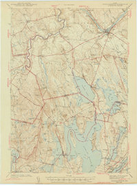
 1950 Lewiston1950 Print · USGSThe Maine and New Hampshire borderlands come alive in this post-war survey of the White Mountains and Androscoggin valley. Genealogists and historians can trace rail lines like the Maine Central Railroad and find high-altitude landmarks from Mount Washington to Bretton Woods.2 unique versions available
 - 1955 Map of Anson, 1957 Print
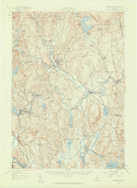
 1955 Anson1957 Print · USGSThe Kennebec River valley in the mid-1950s shows a landscape of busy riverside towns and quiet rural crossroads. Researchers can trace the Maine Central Railroad and find local landmarks like the Union Ch, Purington Sch, and the uniquely named Land of Rest Cem.4 unique versions available
 - 1956 Map of Norridgewock, 1958 Print
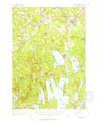 1956 Norridgewock1958 Print · USGSSomerset and Kennebec counties are shown here in the mid-1950s, centered on the river convergence at Norridgewock. Genealogists and historians can trace local school districts like Whittier Sch and explore lakefront landmarks including Camp Abena and The Serpentine.3 unique versions available
 - 1956 Map of Farmington, 1959 Print
 1956 Farmington1959 Print · USGSMid-century Franklin County, Maine, reveals a landscape of river-driven industry and upland farming. Researchers can trace the rail connections through Wilton Station or locate family roots near Knowltons Corner, Intervale School, and Savage Cemetery.3 unique versions available
 - 1956 Map of Bangor, 1966 Print
 1956 Bangor1966 Print · USGSMid-century Maine comes alive in this survey of the rugged coast and river valleys during the 1950s. Genealogists and historians can trace the vital rail corridors of the Maine Central RR connecting timber towns like Old Town to the coast at Bar Harbor.3 unique versions available
 - 1956 Map of Lewiston, 1975 Print
 1956 Lewiston1975 Print · USGSThe Northern New England interior is documented here in the mid-fifties, from the industrial Androscoggin River to the high peaks of the White Mountains. Trace the Grand Trunk Railway through mountain passes or locate family landmarks near Sabbathday Lake and Bretton Woods.
 - 1960 Map of Bangor
 1960 Bangor1960 Print · USGSCentral Maine in the sixties reveals a landscape of river-powered industry and sprawling coastal island chains. Researchers can trace the rail corridors of the Maine Central or locate mid-century aviation landmarks like Dow Air Force Base.
 - 1961 Map of Bangor
 1961 Bangor1961 Print · USGSMid-century Maine comes alive through its busy river ports and rocky archipelagoes during a period of steady maritime and rail commerce. Researchers can trace the path of the Maine Central railroad and locate coastal landmarks from Acadia National Park to Vinalhaven Island.
 - 1961 Map of Lewiston
 1961 Lewiston1961 Print · USGSWestern Maine and the White Mountains appear here during the early sixties, showing the industrial river towns and vast timberlands before the modern interstate era. Genealogists and historians can trace the Grand Trunk RR through Berlin or locate landmarks like Old Speck Mountain and Elephant Mountain.
 - 1962 Map of Lewiston
 1962 Lewiston1962 Print · USGSThe industrial river valleys and high peaks of Maine and New Hampshire define the region in the early sixties. Trace the rail-and-river network from Lewiston to the White Mountains, passing through mill towns like Berlin and Rumford.
 - 1968 Map of New Sharon, 1971 Print
 1968 New Sharon1971 Print · USGSFranklin County in the late sixties shows a landscape defined by riverside settlements and upland farms. Researchers can trace historic burial sites like Village Cem or locate the old mill sites at Allens Mills and Weeks Mills along the Sandy River.
 - 1969 Map of Lewiston
 1969 Lewiston1969 Print · USGSThe northern New England highlands come into focus during the mid-fifties, showing the vital rail and river networks connecting industrial centers to the deep woods. Researchers can trace the path of the Grand Trunk RR or locate landmarks like Mt Washington and Rangeley Lake.
 - 1975 Map of Norridgewock NW, 1980 Print
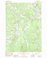
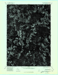 1975 Norridgewock NW1980 Print · USGSCentral Maine in the mid-seventies is revealed through this detailed orthophoto of the winding Sandy River valley. Genealogists and historians can trace the rural layouts of Starks and Mercer or locate homesteads along Bog Stream.
 - 1976 Map of Anson SW, 1980 Print
 1976 Anson SW1980 Print · USGSSomerset County river settlements and timberlands are captured in this mid-seventies aerial study. Trace the industrial and residential footprints along the Kennebec River through Anson, North Anson, and Madison.
 - 1979 Map of New Vineyard, 1983 Print
 1979 New Vineyard1983 Print · USGSFranklin County's wooded hills and remote settlements are captured in this late 1970s aerial survey. Trace rural homesteads and land patterns around New Vineyard, West Mills, and the slopes of the New Vineyard Mountains.
 - 1982 Map of Mercer, 1983 Print
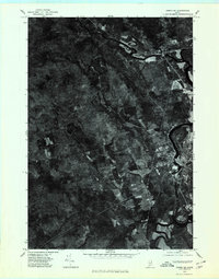
 1982 Mercer1983 Print · USGSSomerset County's rural river valleys are shown in detail during the late twentieth century as traditional crossroads communities remained the focus of local life. Researchers can locate family burial sites like Hampshire Hill Cem or trace the early footprint of Beech Hill Airport and Starks Ch.
 - 1985 Map of Skowhegan, 1986 Print
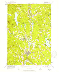
 1985 Skowhegan1986 Print · USGSCentral Maine in the mid-eighties shows a landscape of river-driven industry and rural crossroads. Genealogists can trace family names and farmsteads near Lake George or along the Maine Central Railroad through Pittsfield and Burnham.2 unique versions available
Showing maps 1-25 of 49
Top cities near Starks
- Farmington historical maps
- Fairfield historical maps
- Skowhegan historical maps
- Oakland historical maps
- Madison historical maps
- Sidney historical maps
See more
Top neighborhoods of Starks
Frequently asked questions
- What are the different types of historical maps available for Starks?
- What is the oldest map of Starks?
- Where can I purchase historical maps of Starks for my home or office?
- Where can I download high-res historical maps of Starks?
- Are there historical topographic maps available for Starks?
- Is there historical aerial imagery available for Starks?
- Where are historical maps of Starks sourced from?